What is recorded here
National Monument No. 53. In the NW corner of a graveyard (KE066-016002-), c. 18.7m from the NW corner of the church (KE066-016001-). The base of a circular tower (SW elevation H c. 5.5m; int. diam. at base c. 2.28m; T c. 1.4m; c. 16.5m) consisting of rectangular sandstones bonded with lime and sand mortar. Stones of different sizes were used in its construction: the larger more uniform stones are well-coursed; the smaller stones are uncoursed. Hitchcock (1854) states that the stones were brought from some distance as none are to be found in the local neighbourhood. According to Allen (1892, 166), when Dr. Petrie first saw the tower it was 'more than twenty feet [6.09m] high, and had a doorway twelve feet [3.65m] above the ground'. The 'Proceedings' of J.R.S.A.I. in 1890 record that 'many of the blocks...which formed part of the outer facing of the wall have been abstracted, and used as headstones in the cemetery adjoining'. O'Donovan (1841) states that it is called by both the 'Bishop's Chair'/Cathair An Easpuig - as Aghadoe is a Bishop's See - and as the 'Pulpit' - because it was used by officiating clergy to address the congregation. According to Barrington (1999, 202), the building of the round tower began in 1027. Round tower described by Lalor (1999, 155) as follows; 'Without the valuable record of Lord Dunraven's photograph (c. 1875), it would be difficult to form any impression of the true appearance of the tower [H 5.5m; base diam. 4.6m]. Originally, it was constructed of irregularly coursed and joggled red sandstone blocks, well worked and trimmed to the curve. All other facing stonework (the majority of which is now visible), must be considered modern intrusions. The surviving masonry here exhibits a characteristic manner common to many towers, where the horizontality of the courses is not maintained and they tend to sag noticeably. Around the eleventh course of the squared ashlars from the ground the horizontal plane has been lost by the masons, but recovered in the courses above. The graveyard wall undercuts the north face of the tower. Revised by: Caimin O'Brien
Date of revised upload: 9 May 2022
National Monument No. 53. In the NW corner of a graveyard (KE066-016002-), c. 18.7m from the NW corner of the church (KE066-016001-). The base of a circular tower (SW elevation H c. 5.5m; int. diam. at base c. 2.28m; T c. 1.4m; c. 16.5m) consisting of rectangular sandstones bonded with lime and sand mortar. Stones of different sizes were used in its construction: the larger more uniform stones are well-coursed;…
From the National Monuments Service (Archaeological Survey of Ireland) record KE066-016006
The monument record does not grant public access. Check the route and ask the landowner before entering private land.
- What survives
- Recorded monument
Places near here
Photo credits
- Mike Searle, Geograph · CC BY-SA 2.0
- Berthold Strucken, Wikimedia Commons · CC BY-SA 4.0
- Bkwillwm, Wikimedia Commons · CC BY-SA 3.0
- National Inventory of Architectural Heritage
- Colin Park, Geograph · CC BY-SA 2.0
- Adrian Beney, Wikimedia Commons · CC BY-SA 2.0
- Mike Murphy ( talk · contribs ), Wikimedia Commons · CC BY-SA 3.0
- Humphrey Bolton, Geograph · CC BY-SA 2.0
- EecherplazGinkgo06.jpg : Cayambe derivative work: Ginkgotree ( talk ), Wikimedia Commons · CC BY-SA 3.0
- Marathon, Geograph · CC BY-SA 2.0
 Aghadoe Church (in Ruins)Church · 34 yd
_1.jpg/250px-Aghadoe_(Early_Medieval_Ecclesiastical_Site)_1.jpg "Photo: Berthold Strucken, Wikimedia Commons · CC BY-SA 4.0") Aghadoe Early Medieval Ecclesiastical SiteHeritage attraction · 70 yd
Aghadoe Early Medieval Ecclesiastical SiteHeritage attraction · 70 yd Parkavonear CastleCastle · 130 ydEnclosure in ParkavonearEnclosure · 595 ydEnclosure in ParkavonearEnclosure · 744 yd
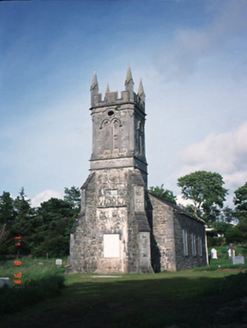 Aghadoe ChurchChurch/chapel · 1289 yd
 Circular WalkWalking route · 1.6 mi
 Lamb IslandIsland · 1.7 mi
 Giant Sequoia1.9 mi
 River WalkWalking route · 2.0 mi
 Ginkgo2.0 mi
 Monsignor Hugh O'Flaherty MemorialMemorial · 2.3 mi
More archaeology and monuments in County Kerry · All of County Kerry
What do you know about this place?