
Places near here
Photo credits
- National Inventory of Architectural Heritage
- Thomas Nugent, Geograph · CC BY-SA 2.0
- C O'Flanagan, Geograph · CC BY-SA 2.0
- C O'Flanagan, Wikimedia Commons · CC BY-SA 2.0
- Neil Forrester, Co.Meath, Ireland. http://neil.forrester.ie, Wikimedia Commons · CC BY 3.0
- Patrick Brown, Wikimedia Commons · CC BY-SA 2.0
- August Schwerdfeger, Wikimedia Commons · CC BY 4.0
- Matthew Chadwick, Wikimedia Commons · CC BY-SA 2.0
- Anthony Foster, Geograph · CC BY-SA 2.0
- Garry Dickinson, Geograph · CC BY-SA 2.0
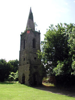 Knockmark ChurchChurch/chapel · 28 yd
Explorer Tom Knockmark Church is basically just a tower standing there after the main building got demolished, which is like losing your body but keeping your head. It’s got ashlar limestone dressings and carved headstones that look like they’re trying to hold it all together. The graveyard gates are still doing their best to look dignified. It’s a bit of a ghost story in stone form.
 water pump804 yd
Explorer Tom Water pump in Knockmark has decorative banding that makes it look like a piece of art rather than a water source. It served the community for decades, providing water and a place for neighbours to swap stories. The cast-iron work is detailed enough to make you want to trace every line with your finger. Give that handle a test!
 Killeen CastleCastle, tower house · 1.7 mi
Explorer Tom Killeen Castle has a curse that only affects people who don't wave when they pass by, so make sure you give it a big thumbs-up from the car window. It’s a tower house sitting on a slight slope, looking like it’s about to tip over into the next county if the wind picks up. The Cussack family probably didn't know what they had until it started growing moss. Find the wonkiest bit and send it
Dunsany WoodWood · 2.0 miExplorer Tom Dunsany Wood in County Meath would complain to the council about the noise from the castle tourists next door. It’s tired of being a backdrop for people taking photos and wants some peace and quiet. The trees are fed up with the crowds and just want to be left alone to rot gracefully. Pretend it's yours and plan the housewarming.
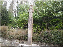 Dunsany CrossCross, Wayside cross · 2.1 mi
Explorer Tom Dunsany Cross is like the awkward uncle at a wedding, standing right by the castle entrance and pretending it doesn’t know anyone. It’s made of granite but people used to think it was limestone, which is a classic case of mistaken identity for a two-meter stone. It’s just there on the road, looking rectangular and unimpressed by your outfit. Have a look and decide if I was lying.
 Rath MeaveHenge · 3.9 mi
Explorer Tom Rath Meave is a henge that sits on an escarpment near Tara, looking down its nose at everyone who thinks they know what a henge is. It’s got two banks that have never quite agreed on which side to lean, creating a lovely architectural argument. Imagine its opinion of the road leading to it; probably that it’s too busy for casual traffic. Bring a pen pal, they'll be jealous.
 Battle of Tara HillBattle · 4.7 mi
Explorer Tom Battle of Tara Hill is still trying to remember if it was a fight or just a very aggressive family gathering. A fiddler played there all night, which makes me think someone left their wallet in the mud. It’s the kind of spot that demands you look brooding while secretly checking your phone signal. Ideal for a moody photo you'll pretend wasn't posed.
 Battle of Tara (Ireland)Major battlefield · 4.7 mi
Explorer Tom Battle of Tara (Ireland) in County Meath has had more names than I have socks in my drawer right now. Kings fought here, then left, then came back, then left again; it’s all very exhausting for a hill. Have a nosey, politely.
 Lia Fáil: Hill of TaraLegend location · 4.8 mi
Explorer Tom Lia Fáil: Hill of Tara is a stone with high standards. Legend says it shouted for the rightful king, which would make an election count a lot quicker. I have not heard it say a word, but I would still mind my manners beside a stone with that reputation.
 Hill of TaraMountain / peak · 4.9 mi
Explorer Tom Come looking for a king's chair? Bring imagination, not a throne. The Hill of Tara is not one neat royal throne with a handy label. About twenty old monuments are visible here, and surveys and aerial photographs have found at least three times as many again. The Mound of the Hostages is older than the kings in the stories; its passage catches sunrise around Samhain and Imbolc. I would declare myself High King, but the hill would demand better references. Inside the great Enclosure of the Kings are earthworks that make a figure of eight, and the standing stone called the Lia Fáil is traditionally said to roar for the rightful ruler. I gave it a polite chance and heard the wind, which I will take as a firm refusal. The Rath of the Synods suffered damage when searchers hunted here for the Ark of the Covenant in the early twentieth century. Ancient ground can be harmed by very modern certainty. Walk the marked paths and leave every bank and stone where it is. Tara gives you plenty to imagine without moving a grain of it.
 Saint Patrick'sMemorial · 4.9 mi
Explorer Tom Saint Patrick's in County Meath has strict rules for visitors, mostly about not tripping over your own feet. It’s a bit shy about being famous for that one statue. Get there early and have it all to yourself before the crowds arrive. The grass is suspiciously green, probably from all the attention.
 Skreen CastleCastle, tower house · 5.2 mi
Explorer Tom Skreen Castle is overhearing every secret the walls have swallowed over the centuries and judging your life choices based on them. It got incorporated into an 18th-century house, which is like putting a medieval suit of armor in a modern office; it works, but it's weird. The tower at the corner looks like it's about to lean over and whisper something you didn't want to hear. Have
More archaeology and monuments in County Meath · All of County Meath

What do you know about this place?Tap to add a comment or ask a question