
Places near here
Photo credits
- Mr. Tom Daly R.I.P., Wikimedia Commons · Public domain
- National Inventory of Architectural Heritage
- Willow, Wikimedia Commons · CC BY 2.5
- J. Stirling Coyne, Wikimedia Commons · Public domain
- Ronnie Nijboer, Wikimedia Commons · CC0
- Paul Mc Carthy, Geograph · Creative Commons Attribution-ShareAlike 2.0
Explorer Tom Ecclesiastical enclosure in Drumlargan seems to have wandered into the wrong parish and hasn’t had the nerve to move out yet. It’s tucked away on a slope, looking like it got lost between a churchyard and a field bank, which is frankly embarrassing for a holy spot with such a vague postcode. The ditch is so subtle you’d miss it if you weren't already squinting. Tell your mates
 Summerhill HouseRuins · 1.2 mi
Explorer Tom Summerhill House in County Meath would have been a brilliant history teacher if it had to explain why it fell down, but it’s too busy looking ruined. It probably spent its last century debating whether to collapse gracefully or just tip over sideways like a drunk giant. Bring your own legend, I've run out.
CastleCastle, tower house · 1.4 miExplorer Tom Castle at Summerhill Demesne wants to lose five stones by New Year, which is ambitious for a ruin. The Lynches have been hanging around since 1421, so it’s got commitment issues too. A good place to forget your phone for ten minutes.
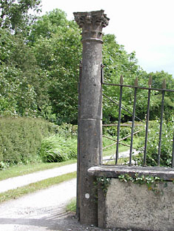 Spring Valley HouseDemesne walls/gates/railings · 1.5 mi
Explorer Tom Spring Valley House in County Meath has a pair of Corinthian columns at the entrance with carved capitals that are just showing off their artistic chops. These gates and railings form part of a larger demesne group, so it’s not just a random fancy door, but a whole coordinated effort by skilled craftsmen. The columns stand there looking
Kilgar GardensHeritage attraction · 2.0 miExplorer Tom Kilgar Gardens in County Meath has the weather on a long grudge list because it keeps raining on the roses specifically to be annoying. It’s a heritage attraction that knows it looks good but hates having its photo taken in bad light. Find a local and ask them the real story, then come back and tell me.
 European ash2.0 mi
Explorer Tom European ash in County Meath is the rabbits’ favourite playground, and they think it owes them rent for living there. It’s got a vibe that says “don’t touch me” but invites you to anyway. Take a breath of that air, it's older than your car.
Larchil Arcadian GardensHeritage attraction · 2.6 miExplorer Tom Larchill is what happens when a farm decides ordinary fields are too sensible. Robert Prentice began turning the Meath estate into an ornamental landscape after leasing it in 1708. Later owners added follies and other carefully arranged surprises. By 1994 the lake had been drained, the walled garden was used for grazing and several follies were in poor shape; new owners set about restoring them. I would build one decorative tower and spend the rest of my life explaining why it was necessary. The grounds are privately managed, so check current opening, booking and permitted paths before visiting. Wander from feature to feature without assuming every odd building had a practical job. Here, making a visitor grin was sometimes the job.
MullaghMountain / peak · 3.1 miExplorer Tom Mullagh is sitting there looking so unimpressed that I think it might be judging your footwear choices from up high. A cow once tried to buy it with a very confident moo, but Mullagh didn't even blink. It’s just a hill that thinks it’s a fortress, which is a bit of a stretch. Bring your nan, she'll know more than me.
Old Bog Road made famous by Teresa Bryton 1868-1943Memorial · 3.5 miExplorer Tom Teresa Bryton allegedly once dropped her tea on this road and the steam rose so high it touched the clouds. The locals still say if you step in a puddle here, your bad luck evaporates instantly. Snap one photo, then put the phone away and actually look.
 Dangan CastleCastle, tower house · 3.5 mi
Explorer Tom Dangan Castle thinks Dublin tourists are all wind and no substance because they never stay long enough to appreciate the quiet. It’s been passed down through families so many times it probably has three different surnames in its head. Tell it a joke, it's been a long time since anyone did.
 Wych Elm4.2 mi
Explorer Tom Wych Elm in County Meath is being claimed by a local who says he invented it. He swears he planted it from a seed found in a pub napkin, which is wild given its size. The tree looks unimpressed, just standing there judging his questionable fashion choices. Visit, then text me what you think. I'll pretend to read it.
 Grave YardGraveyard · 4.6 mi
Explorer Tom Graveyard in Cloncurry nearly got famous when someone tried to digitize its records in the nineties, but the internet was too slow. It sits right next to a motte, looking like a very serious neighbor. If anyone asks, Tom sent you.
More archaeology and monuments in County Meath · All of County Meath

What do you know about this place?Tap to add a comment or ask a question