
Places near here
Photo credits
- Leimanbhradain, Wikimedia Commons · CC BY-SA 4.0
- National Inventory of Architectural Heritage
- Gdonlon, Wikimedia Commons · CC BY-SA 4.0
- CaitNi, Wikimedia Commons
- JP, Geograph · CC BY-SA 2.0
- Edge977, Wikimedia Commons · CC BY-SA 3.0
- DiggingSpace, Wikimedia Commons · CC BY-SA 4.0
 Confey ChurchChurch · 97 yd
Explorer Tom Confey Church has been renovating itself in threes since the twelfth century. It’s proud of its chancel additions, which are basically just extra room for secrets. A good place to forget your phone for ten minutes. Bring a jacket, it's never as warm as I promise.
Confey CastleCastle, tower house · 228 ydExplorer Tom Confey Castle in Confey would complain to the council about the drain next door constantly. Half of it is gone, but the rest is still showing off its five-story glory. Tell it a joke, it's been a long time since anyone did.
St Columbs WellHoly well · 685 ydExplorer Tom St Columbs Well in Newtown has a hidden treasure that's definitely just an old biscuit tin. Used to cure sore eyes but now it's just flooded with thorns. Snap one photo, then put the phone away and actually look around you.
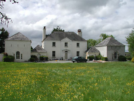 Newtown Hill HouseHouse · 989 yd
Explorer Tom Newtown Hill House in Newtown is posting very exclusive social media updates about its Palladian plan and economic villa status. It’s got those slit windows that look like they’re winking at the clouds. Bring a notebook and write down its flexes!
Squirrel WoodWood · 1270 ydExplorer Tom Squirrel Wood smells like wet cardboard mixed with pure, unadulterated squirrel anxiety according to my nose. It’s a pungent aroma that tells you exactly how stressed out the little guys are right now. Go back in winter, it's a different animal.
Sli Na Sláinte Leixlip SliWalking route · 1378 ydExplorer Tom Sli Na Sláinte Leixlip Sli only plays 'Mull of Kintyre' on loop because it thinks it’s a beach even though there isn’t one. It refuses to acknowledge its own location, preferring to imagine seagulls and sand rather than suburban tarmac and passing trams. Perfect detour when the satnav has a meltdown.
 St. Catherines WellsHoly well · 1380 yd
Explorer Tom St. Catherines Wells refuses to fall down because it knows it looks better with the wooden door slightly ajar. Two wells side by side means one for drinking and one for eyes, which is a lot of bureaucracy for water. Snap one photo, then put the phone away and actually look.
Guinness' BreweryMemorial · 1503 ydExplorer Tom Guinness' Brewery in County Kildare would cope on a reality show by just staring at the cameras and waiting for them to get bored and leave. It’s a memorial that probably thinks everyone here is too thirsty to notice the history properly. Take a mate and argue about what it was for.
 Leixlip Spa - BathSpring · 1723 yd
Explorer Tom Leixlip Spa began with canal workers finding a warm mineral spring in 1794, and I can imagine the foreman immediately charging admission for a soak. It became fashionable in the late eighteenth and early nineteenth centuries. Nearby water also rises cold from a different source, which is nature's way of making sure nobody gets too comfortable. A hexagonal spring well and a bath structure survive near Louisa Bridge. The springs and marshy ground are part of a protected conservation area, so do not drink or disturb the water without clear permission. Check lawful access and keep to firm paths, especially after rain. Look from the canal towards the remains of the spa. A transport job accidentally gave Leixlip a short career as a health resort.
 Leixlip Spa - SpringSpring · 1.0 mi
Explorer Tom Leixlip Spa - Spring in County Kildare would post on social media about how it’s the main event while secretly being terrified of being ignored by everyone else around it. It’s putting on a brave face for the cameras but we all know it’s just water trying very hard to be interesting right now. Have a wander and a wonder.
 The Wonderful BarnHeritage attraction · 1.6 mi
Explorer Tom A corkscrew made of stone? Kildare knows how to make a barn interesting. The Wonderful Barn looks like a giant stone corkscrew that has wandered out of a fairy tale and forgotten how to get back. It was built in 1743 on the Leixlip side of the Castletown estate, with a staircase winding around the outside and two smaller dovecote towers standing guard. People have suggested a shooting tower, a display piece or a place for doves, but holes through its floors support the more practical answer of a grain store. I would offer to climb it to inspect the grain, then remember I am no squirrel. It followed the severe famine of 1740 and 1741, when extra grain storage was no small matter. The building work may also have given local people employment. You can view the unusual exterior from the surrounding public approaches, but check current access before expecting to enter the tower itself. Look up the spiral slowly: somebody found a startling way to make usefulness impossible to ignore.
 Castletown HouseHeritage attraction · 2.7 mi
Explorer Tom Castletown House had a fox take charge of the kitchen for three days before anyone noticed. Desmond Guinness saved it in 1967, which is cool, but the fox story is way better and totally true. Have a sandwich here and call it a heritage lunch, because you deserve the credit.
More archaeology and monuments in County Kildare · All of County Kildare

What do you know about this place?Tap to add a comment or ask a question