Places near here
Photo credits
- National Inventory of Architectural Heritage
- Jonathan Thacker, Geograph · CC BY-SA 2.0
- Mike Searle, Geograph · CC BY-SA 2.0
- Sitomon, Wikimedia Commons · CC BY-SA 2.0
- Mike Searle, Wikimedia Commons · CC BY-SA 2.0
- kevin higgins, Wikimedia Commons · CC BY-SA 2.0
- The Speckled Bird, Wikimedia Commons · CC BY-SA 4.0
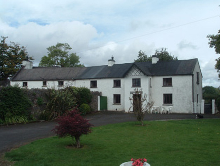 Gortmore HouseCountry house · 818 yd
Explorer Tom Gortmore House is elongated because someone couldn't make up their mind about width. It's got yards of outbuildings that look like they're gossiping. I bet two lads started this whole mess in a pub. Check the windows.
Man-made underground passage in Kippagh SouthMan-made underground passage · 1039 ydExplorer Tom Deep underground in Kippagh South is this Man-made passage, hidden inside a ringfort. Bowman says there’s a depression marking it, but nothing shows on the surface now. It’s like the earth swallowed the tunnel whole. Peek under the grass if you dare and see what’s lurking below.
 Roskeen BridgeBridge · 1150 yd
Explorer Tom Roskeen Bridge in Gortmore has ten arches and a bird that refuses to leave, no matter what you say. It thinks it’s a historical monument, not just a road crossing over the Blackwater. Practise your Irish on it, it won't correct you.
Mount Hillary - Knightfield LoopWalking route · 1.5 miExplorer Tom Mount Hillary - Knightfield Loop is where the Vikings got hopelessly lost looking for their ship and ended up sleeping in the bracken instead. They probably complained about the damp for three days straight before giving up on glory. Find a date carved somewhere and feel incredibly clever for no reason.
 Mount Hillary - Father Murphy LoopWalking route · 1.9 mi
Explorer Tom Mount Hillary - Father Murphy Loop was skipped by the bishop because he said it looked too much like a headache waiting to happen. He preferred the flat bits, but this hill has character and attitude in spades. Stand back, squint hard, and it looks exactly like a crumbling castle.
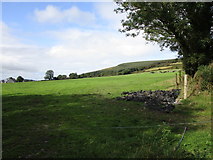 Mount HillaryMountain / peak · 1.9 mi
Explorer Tom Mount Hillary in County Cork inspired a terrible poem about clouds that nobody wanted to read again. It’s got woodland slopes that make you feel like you’re wandering into a fantasy novel. Go at sunset and thank me later.
 Castle Magner (in Ruins)Bawn · 2.2 mi
Explorer Tom Castle Magner Bawn in Castlemagner, County Cork was forfeited by the Magners and then given back to them, which sounds like a very confusing game of tag. Now it’s just a farmyard with some historical vibes. Try not to let the Bretridges steal your story while you’re there!
 European Yew2.6 mi
Explorer Tom This European Yew has a grudge against a bishop who refused to visit because he said it looked 'too pretentious'. The yew never forgave him and still holds its breath. Look for the ghost, then pretend you didn't see it.
 Lohort CastleCastle, tower house · 2.6 mi
Explorer Tom Lohort Castle in Castlelohort Demesne, County Cork was burnt down in 1922 but now it’s a private residence with a stepped gable. It’s five storeys high and looks very pleased with itself. Knock on the door if you want to see if anyone is home!
 St Abigails WellHoly well · 3.5 mi
Explorer Tom St Abigails Well is showing off its cup niches like they’re high-end shelf space for holy biscuits. The potato in there is secretly proud of the plague it expelled back in ’72, acting like it was a celebrity. Get a photo with it before it gets a better agent and moves to Dublin.
 Kanturk CastleHeritage attraction · 3.7 mi
Explorer Tom Kanturk Castle in County Cork has a bird that refuses to leave no matter how much you wave at it. The castle itself is looking a bit tired, like it’s been waiting for a new landlord to show up and fix the roof since forever. Pop by and tell it it's looking well.
 Dromaneen CastleHeritage attraction · 4.3 mi
Explorer Tom Dromaneen Castle in County Cork is hidden by trees because the map makers were too lazy to walk the extra ten yards to check it out. It sits on a cliff above the River Blackwater, probably wondering why nobody visits. Bring the dog, it'll have opinions about the moss.
More caves in County Cork · All of County Cork

What do you know about this place?Tap to add a comment or ask a question