
What is recorded here
At N end of St Abigail's Burial Ground (14117). Circular stone-lined well enclosed by D-shaped stone-built corbelled structure (wall c. 1.77m thick). Splayed entrance ope (H 1.38m; Wth 1.45m) to E with niche in wall on either side for cups (Grove White 1905-25, vol. 3, 341). Steps down to well inside entrance. Still in holy use; crosses engraved by pilgrims on stones around well. 'St Abigail expelling the plague 1872' inscribed on slab over entrance. Grove White (ibid.) noted 'carved figure about six inches long and three broad' over inscription. Berry (1905, 53) described 'rude painting...representing St Abigail kneeling before an altar, expelling the plague'. Removed from inside and re-erected outside after which paint came off and design 'cut in relief' only remained. Grove White (ibid.) in May 1902 recorded second similarly inscribed stone on S side of structure also requesting prayers for souls in purgatory and erectors of stone, dated 1874; strips of linen were tied to branches; he was informed that Mr John O'Callaghan who resided nearby repaired masonry and added inscriptions. Was called 'Johnny the Prayers' and was buried nearby. Well visited on February 11th and rounds paid (Bowman 1934, 540). According to Kavanagh (1991, 21), footpath links Shansepeal (14733) to here.
At N end of St Abigail's Burial Ground (14117). Circular stone-lined well enclosed by D-shaped stone-built corbelled structure (wall c. 1.77m thick). Splayed entrance ope (H 1.38m; Wth 1.45m) to E with niche in wall on either side for cups (Grove White 1905-25, vol. 3, 341). Steps down to well inside entrance. Still in holy use; crosses engraved by pilgrims on stones around well. 'St Abigail expelling the plague…
From the National Monuments Service (Archaeological Survey of Ireland) record CO041-031002
The monument record does not grant public access. Check the route and ask the landowner before entering private land.
- What survives
- Recorded monument
Places near here
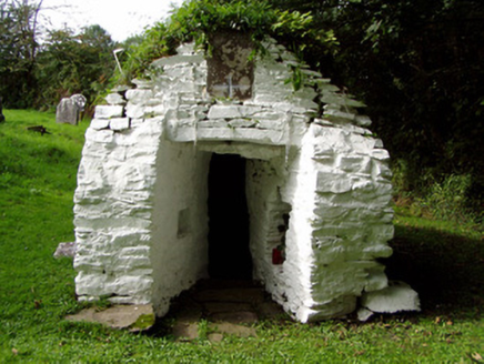 Saint Abigail's WellHoly well · 1 yd
 Lombardstown HouseCountry house · 1.3 mi
 Dromaneen CastleHeritage attraction · 2.8 mi
 Mount HillaryMountain / peak · 2.8 mi
 Graveyard3.3 mi
 Mount Hillary - Father Murphy LoopWalking route · 3.7 mi
 LisheentoortaghFairy fort / earthen ringfort · 3.8 mi
 Eagle's NestMountain / peak · 4.0 mi
.jpg/250px-Castles_of_Munster,_Lohort,_Cork_(geograph_1393402,_high-res).jpg "Photo: Mike Searle, Wikimedia Commons · CC BY-SA 2.0") Lohort CastleCastle, tower house · 4.4 mi
Lohort CastleCastle, tower house · 4.4 mi Castle Magner (in Ruins)Bawn · 5.0 mi
 European Yew5.8 miEuropean Yew5.8 mi
Pictures: National Inventory of Architectural Heritage; Mike Searle, Wikimedia Commons · CC BY-SA 2.0; Jonathan Thacker, Geograph · CC BY-SA 2.0; Mike Searle, Geograph · Creative Commons Attribution-ShareAlike 2.0; Tim Sheerman-Chase, Wikimedia Commons · CC BY 2.0; Mike Searle, Geograph · CC BY-SA 2.0; Sitomon, Wikimedia Commons · CC BY-SA 2.0
More archaeology and monuments in County Cork · All of County Cork
What do you know about this place?