What is recorded here
From OpenStreetMap (© OpenStreetMap contributors) n3744679743
Places near here
Picture notes
- Computer-made picture. It does not show this monument.
- National Inventory of Architectural Heritage
- Andreas F. Borchert, Wikimedia Commons · CC BY-SA 4.0
- Computer-made picture. It does not show this walking route.
- Greg Clarke, Wikimedia Commons · CC BY 2.0
- Kenneth Allen, Wikimedia Commons · CC BY-SA 2.0
- Computer-made picture. It does not show this playground.
- Kenneth Allen, Geograph · CC BY-SA 2.0
 Field system in CrockahennyField system · 1.2 miComputer-made picture. It does not show this monument.
Explorer Tom Field system in Crockahenny first came to notice when a 1997 field walk crossed four old boundaries along a proposed wind farm road. Their stones were deeply set in soil and the first survey suggested a possible prehistoric system. A later survey recorded two distinct groups. The map grew more complicated with another look.
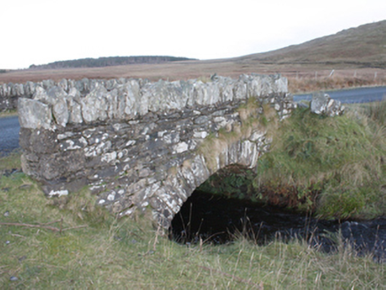 Strath BridgeBridge · 1.7 mi
Explorer Tom Strath Bridge spans the Meenatomish River in one round arch from around 1850. It may have been part of Famine relief work; the record notes that it is absent from an 1837 map. I can count the arch, but the bridge’s reason for being built is still a possibility.
 Giants GraveMegalithic tomb · 2.0 miComputer-made picture. It does not show this monument.
Explorer Tom Giants Grave is now just a few stones stuck into an earthen field fence. It’s a total mess of broken history, but the name does most of the heavy lifting for you. You’re basically looking at a very sad, very small graveyard.
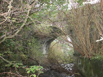 Drumskellan BridgeBridge · 2.2 mi
Explorer Tom Drumskellan Bridge was built around 1800 with one round arch over a small stream. The bridge keeps the road level, and an 1837 map shows old tuck and flax mills downstream. I thought the water was a minor character; the old map gives it two jobs.
 Eskaheen GraveyardGraveyard · 2.6 mi
Explorer Tom Eskaheen Graveyard lies on high ground looking over Lough Foyle. The earlier survey recorded part of the old church's west gable and a small south wall section, with an opening that might have been a door or window. I want to leave that uncertainty in: 4.4 metres of stone can tell us plenty, but cannot name every missing part.
 Cruckahenny TrailOfficial walking route · 3.3 miComputer-made picture. It does not show this walking route.
Explorer Tom Cruckahenny Trail is ten kilometres of pure mystery, with an imaginary twin across the sea that refuses to make contact. It’s like walking into a phone booth from the seventies. Tell me if the gossip I made up is true.
 Muff ForestWoodland walk · 3.3 mi
Explorer Tom Muff Forest's Grania's Gap Loop climbs from Lisnagra Woods to views over Lough Foyle. Sport Ireland marks 6.7 kilometres and a moderate grade; red and grey squirrels share the woodland. Quite a lot of company for one loop.
 Quigley's PointHeadland · 3.5 mi
Explorer Tom Near Quigley's Point, United States Navy seaplanes flew from a Lough Foyle base in 1918. It closed by February 1919, after crews had built roads, hangars and slipways; quite a lot of building for such a short stay.
 Children's playground3.6 miComputer-made picture. It does not show this playground.
Explorer Tom Children's playground in County Donegal is where kids go to invent new games that involve imaginary dragons and real mud. The sandcastle builder over there is probably the king of this little kingdom right now. Go now, before it gets famous and they put up fences.
 Grania’s Gap LoopOfficial walking route · 3.6 miComputer-made picture. It does not show this walking route.
Explorer Tom Grania’s Gap Loop is named after a woman who probably had better things to do than loop around hills. Six point seven kilometres of moderate misery disguised as a scenic stroll. Bring sandwiches, the gulls will thank you, or steal them entirely.
 Squealin' PigPub · 4.0 mi
Explorer Tom Squealin' Pig is right on the main road, probably hogging all the attention it deserves. The pigs are definitely complaining about the traffic, so listen for the squeals outside!
 FinnegansPub · 4.0 mi
Explorer Tom Finnegans is also on the main road, sharing the spotlight with the Squealin' Pig next door. It’s a bit of a pub cluster here, so just pick one and commit to your choice!
More mountains and hills in County Donegal · All of County Donegal

What do you know about this place?Tap to add a comment or ask a question