
What is recorded here
Near the crest of a low ridge in rolling pasture. Part of a WSW-facing gallery (L c. 3m; Wth 1.2m) and the remains of outer-walling and a facade survive here. Two orthostats are visible on the S side of the gallery. Opposite the western of these there is another orthostat and to the E of this two corbels rising above…
Read the whole record
From the National Monuments Service (Archaeological Survey of Ireland) record SL035-063
Places near here
Photo credits
- Maker not stated on source page, www.pinterest.com
- Maker not stated on source page, commons.wikimedia.org
- Maker not stated on source page, tr.pinterest.com
- Oliver Dixon, Geograph · CC BY-SA 2.0
- Maker not stated on source page, uk.pinterest.com
- Maker not stated on source page, www.pinterest.ru
- Maker not stated on source page, de.wikipedia.org
- Foggyflies, Wikimedia Commons · CC BY-SA 4.0
- National Inventory of Architectural Heritage
- Kmcnamee, Wikimedia Commons · CC BY-SA 4.0
 Fairy fort / earthen ringfort in BallyculleenFairy fort / earthen ringfort · 499 yd
Explorer Tom Fairy fort / earthern ringfort in Ballyculleen would tell you it’s 'proactive' and 'a team player' in its job…
 Megalithic structure in BallyculleenMegalithic structure · 794 yd
Explorer Tom Megalithic structure in Ballyculleen is likely gone, hidden inside a fence, and has an imaginary fan club of very…
 Fairy fort / stone ringfort in Drumbeg WestFairy fort / stone ringfort · 1226 yd
Explorer Tom Fairy fort / stone ringfort in Drumbeg West would describe the 1800s to a teenager as 'a time when everyone was…
 bridge1229 yd
Explorer Tom Bridge in Ballyculleen hates the wind because it keeps picking on its dressed stonework, saying it looks too fancy for…
 Fairy fort / stone ringfort in Cabragh (tirerrill By.)Fairy fort / stone ringfort · 1401 yd
Explorer Tom Fairy fort / stone ringfort in Cabragh is where Father O’Malley lost a bet about whether he could balance a pint on the…
 Shancough ChurchRuins · 1453 yd
Explorer Tom Shancough Church in County Sligo saw its most dramatic moment when a cow wandered into the ruins and refused to leave…
 Fairy fort / earthen ringfort in Dromore (tirerrill By., Kilmactranny Ed)Fairy fort / earthen ringfort · 1464 yd
Explorer Tom Fairy fort in Dromore sits on a ridge looking down its nose at everyone, probably thinking Dublin tourists are just…
 Foyoges Church (in Ruins)Church · 1489 yd
Explorer Tom Foyoges Church: The first owner’s escape plan was clearly 'run fast and hope nobody notices you left the stones…
 Foyoges BridgeBridge · 1525 yd
Explorer Tom Foyoges Bridge in Aughnacloy has a dramatic feud with the big tree next to it over who has better arches. The bridge…
 Granny's WellWater pump · 1543 yd
Explorer Tom Granny's Well in Straduff would have a tombstone reading 'She gave you water, now stop complaining about the taste'…
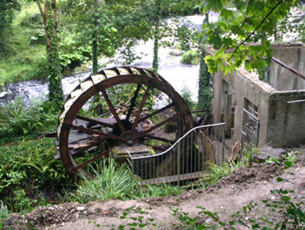 hydroelectric power station1549 yd
Explorer Tom The Hydroelectric power station in Aughnacloy is having a massive fit about modern buildings because it thinks water…
 Geevagh GAAGAA ground · 1.1 mi
More archaeology and monuments in County Sligo · All of County Sligo

What do you know about this place?Tap to add a comment or ask a question