
What is recorded here
From OpenStreetMap (© OpenStreetMap contributors) n3783724992
Places near here
Photo credits
- Maker not stated on source page, www.pinterest.com
- Maker not stated on source page, masterok.livejournal.com
- Kenneth Allen, Geograph · Creative Commons Attribution-ShareAlike 2.0
- National Inventory of Architectural Heritage
- Eric Jones, Geograph · CC BY-SA 2.0
- Ronnie Nijboer, Wikimedia Commons · CC0
- Donegal GAA; photographer not stated, donegalgaa.ie
- Maker not stated on source page, ru.pinterest.com
- Maker not stated on source page, www.airbnb.co.za
- Maker not stated on source page, www.alamy.com
- Donegal Live; individual photographer not named, www.donegallive.ie
 Megalithic structure in Clochar An ChuilinnMegalithic structure · 1.8 mi
Explorer Tom Megalithic structure in Clochar An Chuilinn is just a massive slab propped up on rocks. Some archaeologists are still…
 Bullaun stone in Doire Leac Chonaill TheasBullaun stone · 1.9 mi
Explorer Tom Bullaun stone in Doire Leac Chonaill Theas makes a weird humming sound at night, probably because it’s trying to…
 Traighena National SchoolSchool · 2.1 mi
Explorer Tom Traighena National School has a tall tale about a hidden tunnel to the pub that runs under the T-plan and straight into…
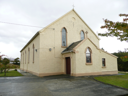 Saint Conal's Catholic ChurchChurch/chapel · 2.7 mi
Explorer Tom Saint Conal's Catholic Church was built in 1833 and altered in 1913. Its pointed windows, stained glass and timber…
 icehouse2.9 mi
Explorer Tom Icehouse in Derrynacarrow is a round stone building set into a hillside, built around 1860. The survey says it was…
 Gweebarra BarPub · 2.9 mi
Explorer Tom Gweebarra Bar sits right on a sharp bend in the N56, waiting for someone to lose control of their vehicle. The seagulls…
 Wych Elm4.3 mi
Explorer Tom Wych Elm claims there’s a shortcut through its branches that saves twenty minutes, but nobody has ever actually found…
 Dooey Park, Na RossaGAA ground · 4.5 mi
 Kilkenny Old Church GraveyardGraveyard · 4.7 mi
Explorer Tom Kilkenny Old Church Graveyard places a rectangle beside the remains of a curve: the survey described the rectangular…
 Dunnarealt FortIslet · 5.2 mi
Explorer Tom Dunnarealt Fort in County Donegal is currently being run by a very aggressive terrier who has never met a stranger he…
 The Old Chapel CafeCafé · 5.9 mi
Explorer Tom The Old Chapel Cafe in Dungloe is closed on holidays, which means the ghosts have a day off too. Imagine it as the…
 Rosses Park, Dungloe GAAGAA ground · 6.0 mi
More mountains and hills in County Donegal · All of County Donegal

What do you know about this place?Tap to add a comment or ask a question