
What is recorded here
From the National Monuments Service (Archaeological Survey of Ireland) record CO051-111002
Places near here
Photo credits
- National Inventory of Architectural Heritage
- Jonathan Thacker, Geograph · Creative Commons Attribution-ShareAlike 2.0
- Frederick Dean, Geograph · CC BY-SA 2.0
- Tim Sheerman-Chase, Wikimedia Commons · CC BY 2.0
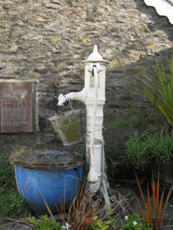 water pump68 yd
Explorer Tom Water pump in Grenagh South would review you like a picky food critic. '3/5 stars, handle was slippery, water was lukewarm.' It’s a lovely cast-iron thing with artistic curves. Tease it gently and see if it pumps back.
 St Laghteen's Roman Catholic ChurchChurch/chapel · 93 yd
Explorer Tom St Laghteen's Roman Catholic Church is plain on the outside but hiding a fancy reredos inside like it’s got a secret party. It thinks it’s very important because of that carving. Bring a pen to scribble down how much you’re pretending to be impressed.
Castle (Site of)Castle, Anglo-Norman masonry castle · 1.5 miExplorer Tom Castle in Knockantota South has no visible trace at all, which is impressive for a building that used to exist. It’s basically a plot of pasture with a reputation. Go on, count the windows and get it wrong like I did.
Pairc Ath Na hEornaMemorial · 1.8 miRock HillMountain / peak · 2.0 miLyradane MountainMountain / peak · 2.0 miGraveyard in KilmonaGraveyard · 2.2 miExplorer Tom Graveyard in Kilmona has no visible trace of burials left, so its dating profile probably says ‘deep inside, loves history, currently unavailable.’ It’s part of an early ecclesiastical enclosure, which means it’s got some serious ancient credentials even if you can’t see them. If anyone asks, Tom sent you.
Garrycloyne Castle (in Ruins)Castle, tower house · 2.9 miExplorer Tom Garrycloyne Castle got demolished in 1948 to build housing walls. The locals used the stones for their gardens, so this is now a very expensive garden feature. No lofty tower left, just a flat patch of regret and grass.
St John's WellSpring · 3.8 mi Island Wedge TombArchaeological place · 4.2 mi
Explorer Tom Island Wedge Tomb is from 2500 BC, so it’s seriously old. It’s on an island, which makes it extra exclusive. Take a photo for me from the shore and tell me if you can hear ghosts!
BatsVisitor information · 4.7 mi LisheenbegFairy fort / earthen ringfort · 5.4 mi
Explorer Tom Lisheenbeg is a heavily overgrown circle with an entrance on the east side. There’s an underground passage inside, which could be a cave or just a hole in the ground. Don't get lost down there!
More archaeology and monuments in County Cork · All of County Cork

What do you know about this place?Tap to add a comment or ask a question