
Places near here
Photo credits
- National Inventory of Architectural Heritage
- abdallahh from Montréal, Canada, Wikimedia Commons · CC BY 2.0
- Gerd Eichmann, Wikimedia Commons · CC BY-SA 4.0
- Joseph Mischyshyn, Wikimedia Commons · CC BY-SA 2.0
- Daniel J Hastings, Wikimedia Commons · CC BY-SA 4.0
- Sitomon, Wikimedia Commons · CC BY-SA 2.0
- Jonathan Thacker, Geograph · CC BY-SA 2.0
- Robert Ashby, Wikimedia Commons · CC BY-SA 2.0
Explorer Tom Fulacht Fiadh in Dawstown was a mound on the south bank of the stream, but now it’s just gone. It showed up on old maps like a ghost that refuses to be exorcised. If it rains, blame me for bringing you to this invisible puddle.
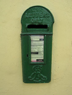 post box446 yd
Explorer Tom Post box in Newcastle is flaunting King Edward’s crown like it owns the place. Installed back in 1905, this iron beauty is still doing its job. Take a pic of the royal insignia before it gets embarrassed.
Castle (Site of)Castle, unclassified · 767 ydExplorer Tom Castle in Newcastle is basically just field fence remnants and some pottery shards found during ploughing. It was a rectangular structure once, but now it's just dirt with historical baggage. Bring a coin for luck and keep it in your pocket.
IndicatedFairy fort / earthen ringfort · 1116 ydExplorer Tom This fairy fort in Dawstown is levelled but still hanging in there like a stubborn relative at Christmas. It’s in pasture, so expect cows to be more interesting than the archaeology. Bring a flask of something warm and a story to swap with the sheep.
 farm house1.2 mi
Explorer Tom Farm house in Monalahy is classically proportioned and symmetrical, which means it’s probably very strict about how you line your plates up. It moved away from vernacular traditions to be fancy, so act accordingly. Don’t sneeze too loud or it’ll think you’re rude.
 Western Redcedar3.7 mi
Explorer Tom Western Redcedar in County Cork hosted a dance once that went way too far and now no one will admit who was there. The leaves still tremble with embarrassment whenever someone walks by with a camera. Find a date carved somewhere and feel clever about it.
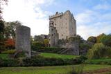 Blarney Castle (in Ruins)Castle, tower house · 3.8 mi
Explorer Tom Blarney Castle in Blarney has a dating profile that says 'I like stone walls and people who don't mind getting kissed on the cheek', which is honestly not a bad approach to finding a partner. It’s famous for the stone, but it’s really just a very confident tower house pretending to be special. Have
 Guard TowerHeritage attraction · 3.8 mi
Explorer Tom Guard Tower in County Cork is famous because a hero nobody remembers saved it from being turned into a very fancy toilet block. We owe him a pint that he’ll never drink now. Sit on a wall near it and pretend you're in a painting.
 Blarney CastleHeritage attraction · 3.8 mi
Explorer Tom Think Blarney is all about kissing one stone? You have been sold short. Blarney Castle has the famous stone at the top, but I would not let one kiss steal the whole visit. The MacCarthys rebuilt the present keep in 1446 after earlier fortifications had come and gone. The Stone of Eloquence sits up among the battlements and machicolations, the projecting openings a castle once used for defence. I would tour the poison garden with my hands in my pockets, which improves my manners everywhere. I would have expected a siege, not a queue of people trying to borrow a better tongue. Below, some rooms survive in this partial ruin, and the grounds take a stranger turn through a poison garden with wolfsbane and mandrake. Please admire the plants with your eyes and leave the touching to the gardeners who know them. There are also named rock formations and paths around the estate, so give yourself time beyond the climb. The castle is a managed visitor attraction with accessible rooms and battlements; follow its marked route. If the stone grants me eloquence, I will spend it telling you about the rest.
 European Yew3.8 mi
Explorer Tom European Yew in Cork is being gossiped about by seagulls who say it's actually two trees pretending to be one. They're probably right because I can't tell where one ends. Find the wonkiest bit and send it to your group chat.
 New TipperaryVisitor information · 5.2 mi
Explorer Tom New Tipperary hosted a dance once where someone actually fell into the well and didn't apologise for two weeks. It’s now just a little info point that’s seen better centuries. Bring the dog, it'll have opinions.
 Curraghkippane CemeteryGraveyard · 5.7 mi
Explorer Tom Curraghkippane Cemetery in County Cork is eavesdropping on the neighbours through its thick stone walls. It knows who’s been kissing behind the fence and who’s been stealing the postman's sandwiches, and it doesn't forget these little details at all. Great spot to propose. Or at least to propose lunch.
More archaeology and monuments in County Cork · All of County Cork

What do you know about this place?Tap to add a comment or ask a question