
Places near here
Photo credits
- Andreas F. Borchert, Wikimedia Commons · CC BY-SA 4.0
- Jonathan Thacker, Geograph · Creative Commons Attribution-ShareAlike 2.0
- dougf, Geograph · CC BY-SA 2.0
- Willow, Wikimedia Commons · CC BY 2.5
- National Inventory of Architectural Heritage
- Maker named on the Wikimedia Commons picture page · Public domain
- Jason Keane, Geograph · CC BY-SA 2.0
- Derek Ryan Bawn, Wikimedia Commons · CC BY-SA 4.0
 Franciscan Abbey (in ruins)Religious house, Dominican friars · 84 yd
Explorer Tom Franciscan Abbey in Lorrha has very strong opinions on modern building standards and probably finds your architecture embarrassing. It’s actually Dominican, which just adds to the mix-up and the general confusion of the ages. It stands there judging every new roofline that dares to appear nearby. Practise your Irish on it, it won't correct you.
 Saint Ruadhan's Catholic ChurchChurch/chapel · 95 yd
Explorer Tom Saint Ruadhan's Catholic Church is sitting right next to old friary ruins that make it look like it’s got a long history of spiritual hangovers. I think it rolls its eyes at Dublin tourists who take selfies in front of the steeple instead of actually listening to the sermon. Just give it a respectful nod from the road and don’t linger too long!
Rodans wellHoly well · 384 ydExplorer Tom Rodans well in Lorrha refuses to fall down because it’s got seven steps leading into it, and it knows people would trip if they weren't careful. It sits next to a priory like it’s waiting for the monks to finally notice it’s still standing. Have a wander around the village and a wonder at how stubborn that stone wall is.
 Ballyquirke castle (in ruins)Castle, tower house · 1.4 mi
Explorer Tom Ballyquirke Castle is proud of one thing: it managed to disappear completely before anyone could take a proper photo. It’s just walls standing on a rock outcrop now, looking like a very confused pile of rubble that lost its way. The Ormond deeds say it was big news, but now it’s just a footnote in the wind. Toast it with a cup of tea and move on to the next.
Ballyquirk CastleCastle · 1.4 miExplorer Tom Ballyquirk Castle is mostly collapsed and ivy-covered, but there’s a fake royal visit in its history that nobody can disprove because everyone died of typhoid. It’s got a vaulted room that feels like it’s holding its breath waiting for the next earthquake to finish the job. Ideal for a moody photo you'll pretend wasn't posed.
Sallow IslandIsland · 2.4 miExplorer Tom Sallow Island is secretly proud of a single potato it grew last summer which it treats like a royal heirloom passed down through generations of dirt. It polishes this spud with a rag and shows it off to anyone who will look at it for even a second. Ideal for a moody photo you'll pretend wasn't posed.
Slevoir BayBay · 2.5 miExplorer Tom Slevoir Bay is having a massive dramatic standoff with the nearest tree, which keeps leaning in too close for comfort. The bay is furious about this and keeps throwing waves at it like little angry fists. It’s a lovely place to watch nature pretend everything is fine while chaos brews. Count the crows, then count again.
 European ash3.3 mi
Explorer Tom European ash wants its tombstone to say 'He was tall, he was cool, and he never once dropped a leaf on your head.' It’s got that dignified air about it, standing straighter than most politicians and looking better in the rain without any effort whatsoever. Pack a picnic and an excuse.
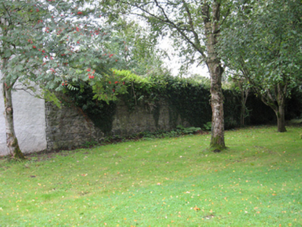 Portumna CastleWalled garden · 3.7 mi
Explorer Tom This walled garden refuses to fall down because it’s too stubborn to admit it’s useless. The bricks are holding on for dear life, mostly out of sheer spite. Pop by and tell it it's looking absolutely magnificent today.
 Black mulberry3.9 mi
Explorer Tom Black mulberry in County Galway once caught a poet’s eye and his boot in a ditch nearby. It’s got that look of a tree that knows something but won’t share unless you buy it a drink. Take a mate and argue about what it was for.
 Church IslandIslet · 5.0 mi
Explorer Tom Church Island has a ghost who is too lazy to haunt it properly because he’d have to walk all the way up the hill and back down again, which is exhausting. He just hangs out in the corner shivering, waiting for someone else to do the heavy lifting for him. Practise your Irish on it, it won't correct you.
 BarrowBarrow, mound barrow · 5.5 mi
Explorer Tom Barrow in Lismacrory is basically a giant stone ear, but locals claim it’s actually a listening post for aliens who just wanted a quiet spot. The name? Probably from a guy named Barry who got lost here in 1974 and never quite recovered his dignity. Whisper a secret at it, it's kept worse.
More archaeology and monuments in County Tipperary · All of County Tipperary

What do you know about this place?Tap to add a comment or ask a question