
What is recorded here
From the National Monuments Service (Archaeological Survey of Ireland) record CW013-133
Places near here
Photo credits
- Maker not stated on source page, www.pinterest.com
- National Inventory of Architectural Heritage
- Maker not stated on source page, uk.pinterest.com
- liam murphy, Wikimedia Commons · CC BY-SA 2.0
- Maker not stated on source page, ph.pinterest.com
- Maker not stated on source page, www.irishmirror.ie
- Maker not stated on source page, www.dreamstime.com
- Hello, I am Bruce on Flickr, Wikimedia Commons · CC BY-SA 2.0
- Colin Park, Geograph · CC BY-SA 2.0
- Maker not stated on source page, en.wikipedia.org
 Castle Grace (in Ruins)Castle, unclassified · 422 yd
Explorer Tom Castle Grace is gone, replaced by outbuildings that don’t even have the decency to look medieval. A stubborn bird…
 Flat cemetery in CastlegraceFlat cemetery · 936 yd
Explorer Tom Castlegrace Flat Cemetery was found during ploughing, which is a bit embarrassing for everyone involved. They dug up…
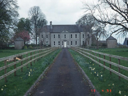 Sandbrook HouseHouse · 984 yd
Explorer Tom Sandbrook House in Ballygarret is a Palladian dream with quadrant walls and a proper frontage. The local sheep probably…
 Bullaun stone in AghadeBullaun stone · 1413 yd
Explorer Tom Bullaun stone in Aghade was once called a baptismal font, which is a stretch for a basin rock. It sits south of an…
 All Saints' Church (Aghade)Church/chapel · 1430 yd
Explorer Tom All Saints' Church in Aghade has two graveyards, which means twice as many things to worry about. It would bring a…
 Aghade GraveyardGraveyard · 1438 yd
Explorer Tom Aghade Graveyard in County Carlow is playing hide-and-seek with me, and it’s winning big time. It claims to be haunted…
 Holy well in AghadeHoly well · 1438 yd
Explorer Tom Holy well in Aghade is basically a Victorian group chat that never got the memo to stop gossiping. It’s been overgrown…
 Graveyard in AghadeGraveyard · 1447 yd
Explorer Tom Graveyard in Aghade has an Augustinian Abbey and a holy well that probably smells like regret. It handles nosey…
 CastleCastle, unclassified · 1.2 mi
Explorer Tom Castle in Ballyvolden is famous for having strict visitor rules that nobody has ever seen because nobody can find the…
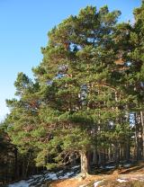 Scots Pine1.7 mi
Explorer Tom Scots Pine in County Carlow is holding a secret that would make sense if I had three more pints. It might be about a…
 Altamont Gardens MapVisitor information · 1.8 mi
Explorer Tom Altamont Gardens Map in County Carlow would bring its own compass to a party and still get lost. It’s all curves and…
 Ballon GAA pitchGAA ground · 2.0 mi
More archaeology and monuments in County Carlow · All of County Carlow

What do you know about this place?Tap to add a comment or ask a question