
What is recorded here
From the National Monuments Service (Archaeological Survey of Ireland) record CO004-023
Places near here
Photo credits
- National Inventory of Architectural Heritage
- Maker not stated on source page, kreafolk.com
- Maker not stated on source page, www.pinterest.com
- Jonathan Thacker, Geograph · CC BY-SA 2.0
- Kmcnamee, Wikimedia Commons · CC BY-SA 4.0
- Maker not stated on source page, irisharchaeology.org
- Maker not stated on source page, uk.pinterest.com
- Maker not stated on source page, se.pinterest.com
- Maker not stated on source page, www.youtube.com
- Maker not stated on source page, nl.pinterest.com
 Breanagh BridgeBridge · 1216 yd
Explorer Tom Breanagh Bridge in Knockaclarig has a postbox built right into its leg, like a shoe with an ankle bracelet. It’s got…
 Church (Site of)Church · 1432 yd
Explorer Tom Church in Knockaclarig is An Teampall, a small enclosure of stones and earth that has since disappeared into the rough…
 Church in CloghvoulaChurch · 1709 yd
Explorer Tom Church in Cloghvoula is playing hard to get, hiding behind stepping stones and zero visible trace. I reckon it took…
 Three CountiesPicnic place · 1.6 mi
Explorer Tom Three Counties in County Cork is a picnic spot right on the border of Limerick and Kerry, so you can eat a sandwich…
 Rockchapel GAA pitchGAA ground · 2.2 mi
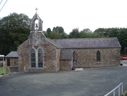 Saint Peter's ChurchChurch/chapel · 3.0 mi
Explorer Tom Saint Peter's Church in Tooreennagrena is dressed to the nines with limestone ashlar and stained glass. Built around…
 Standing stone in Tooreennagrena (bear By.)Standing stone · 3.2 mi
Explorer Tom Standing stone in Tooreennagrena is officially gone, which means you're looking at its ghost or a very convincing pile…
 Standing stone in TooreenclassaghStanding stone · 8.4 mi
Explorer Tom Standing stone in Tooreenclassagh used to be part of a trio until two got bored and left. Now it's just here, looking…
 Stone row in Ummeraboy WestStone row · 9.8 mi
Explorer Tom Stone row in Ummeraboy West, County Cork used to be three stones in a line, but they’ve all been removed now. Bowman…
 Cupmarked stone (present location) in Ummeraboy WestCupmarked stone (present location) · 9.9 mi
Explorer Tom Cupmarked stone in Ummeraboy West, County Cork was dumped against a fence after being moved around in the 80s. Locals…
 Standing stone in Knockeenadallane (duhallow By., Kilmeen Par.)Standing stone · 10 mi
Explorer Tom Standing stone in Knockeenadallane was originally over seven feet high, but now it’s just a stub. Someone broke off the…
 Standing stone in Park (duhallow By., Nohavaldaly Par.)Standing stone · 10 mi
Explorer Tom Standing stone in Park, County Cork used to be part of a pair called 'dallans', but both were removed in the late 1970s…
More archaeology and monuments in County Cork · All of County Cork

What do you know about this place?Tap to add a comment or ask a question