What is recorded here
From OpenStreetMap (© OpenStreetMap contributors) w469661839
Places near here
Photo credits
- National Inventory of Architectural Heritage
- Kenneth Allen, Geograph · CC BY-SA 2.0
- Joseph Mischyshyn, Wikimedia Commons · CC BY-SA 2.0
- P L Chadwick, Geograph · CC BY-SA 2.0
- A McCarron, Wikimedia Commons · CC BY-SA 2.0
- Anne Burgess, Wikimedia Commons · CC BY-SA 2.0
- Robert Bone, Wikimedia Commons · CC BY-SA 2.0
- Eric Jones, Geograph · CC BY-SA 2.0
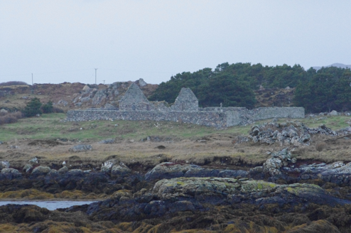 Teampall Cróine [Templecrone]Church/chapel · 1.1 mi
Explorer Tom Teampall Cróine [Templecrone] has stood roofless since c.1620, meaning it has spent four centuries staring straight up at the Donegal sky. I reckon the congregation simply gave up on the weather and decided to let the clouds handle the sermon from now on.
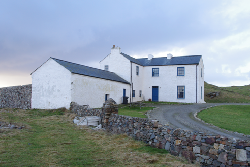 Termon HouseSteward's house · 1.5 mi
Explorer Tom Termon House, built around 1770, has a base that slopes outward, probably to throw rain away from its walls. A raindrop could arrive with a splash and leave with a very offended 'Well, excuse me!' The house overlooks Maghery Bay.
 Strand View BarPub · 1.7 mi
Explorer Tom Strand View Bar probably has a view of the sea and a lot of people staring at it. It's in Donegal, where the wind tries to steal your hat. Go look out the window and feel majestic.
 Inis Mhic an DoirnIsland · 1.8 mi
Explorer Tom Inis Mhic an Doirn is near Rutland Island in County Donegal, part of the Eighter group with historic ferry connections.
 Hook Point / Pointe an DuáinHeadland · 2.0 mi
Explorer Tom Hook Point, or Pointe an Duáin, curls around the water like a friendly wave, waiting for you to take a peek.
 O’Donnell’sPub · 2.1 mi
Explorer Tom O’Donnell’s in Burtonport is called Jimmy Johnny’s by locals, which proves names change. It’s a popular spot where everyone knows your business. Get a drink and listen to the chatter!
 Lough Aghnish Promontory FortPromontory fort, inland · 2.4 mi
Explorer Tom Lough Aghnish Promontory Fort cuts off a peninsula with a stone wall that has a weird, angled entrance. The base is solid, but the top looks like modern repairs. It’s a bit of a puzzle why they built it exactly there.
 CroaghnamaddyMountain / peak · 2.7 mi
Explorer Tom Croaghnamaddy offers a whole view from County Donegal, a peak that seems to be keeping its secrets very closely.
 An tÍochtarIsland · 3.0 mi
Explorer Tom Eighter Island looks like the perfect coastal playground for a long walk, and I would have loved to be dropped off here.
 Cairn on Cnoc an IolairPublicly named cairn · 4.9 mi
Explorer Tom Cairn on Cnoc an Iolair sits on a place that sounds like it’s waiting for a giant eagle to land. Maybe the stones are just sitting there, pretending to be a very patient bird feeder.
 Drumlaghdrid HillMountain / peak · 5.8 mi
Explorer Tom Drumlaghdrid Hill stands in County Donegal with its access details currently unknown. A photograph shows the B7905 road climbing south-eastwards across its flank, six kilometres north of Lettermacaward. It is a bit cheeky for a hill to have such a well-documented road climbing up its side while still keeping its own path a secret!
 Tor an ÉidighHeadland · 6.5 mi
Explorer Tom Tor an Éidigh is recorded as a headland in County Donegal. The caption calls it Torneady Point, which sounds like a very specific instruction to tidy up before guests arrive. I reckon the headland keeps its own schedule.
More islands in County Donegal · All of County Donegal
What do you know about this place?Tap to add a comment or ask a question