DDiscover AloneMapAbout

Drumhome Graveyard

Graveyard

The monument record does not grant public access. Check the route and ask the landowner before entering private land.

What survives
Recorded monument
What do you know about this place?Tap to add a comment or ask a question

What you write will be public.

What is recorded here

Drumhome Old Church (DG103-002001-): Described in 1622 as in need of repair and wanting only a roof (Royal Commission, 214) the church was either repaired or possibly rebuilt and continued in use until 1795 when a new church was erected at Ballintra (Lewis I, 1837, 516; Maguire I, 1920, 383). Built of quarried-blocks…

Read the whole record
Drumhome Old Church (DG103-002001-): Described in 1622 as in need of repair and wanting only a roof (Royal Commission, 214) the church was either repaired or possibly rebuilt and continued in use until 1795 when a new church was erected at Ballintra (Lewis I, 1837, 516; Maguire I, 1920, 383). Built of quarried-blocks and rubble with small pinnings, only the ivy-covered W gable with remnants of a bellcote, survive. The N and S corners and adjoining faces have been replaced in modern times, presumably to prevent collapse. The gable is 8.3m long externally and 1.2m thick. A ragged ivy-covered opening in the upper section of the gable may indicate a window. In the N corner of the graveyard (DG103-002003-) is a low grass covered grave-mound at either end of which is a dressed fragment (DG103-002002-). On the S is a weathered block with late medieval moulding of alternate right angles and cavettos; possibly from a door. On the N is a window jamb fragment; probably of similar date. These undoubtedly came from the parish church. The Church is located in a still-used rectangular graveyard which seems formerly to have been larger in extent. The site is the location of an early ecclesiastical settlement (Gwynn and Hadcock 1970, 35). Excavations undertaken in 2013 uncovered evidence of a large oval-shaped enclosure and stone huts (Irish Times, 29th August 2013). The above description was derived from the 'Archaeological Survey of County Donegal. A description of the field antiquities of the County from the Mesolithic Period to the 17th century.' Compiled by: Brian Lacey with Eamon Cody, Claire Cotter, Judy Cuppage, Noel Dunne, Vincent Hurley, Celie O'Rahilly, Paul Walsh and Seán Ó Nualláin (Lifford: Donegal County Council, 1983), no. 1598. Attached image: DG103-002003-_01 Date of upload: 4 September 2013

From the National Monuments Service (Archaeological Survey of Ireland) record DG103-002003

Places near here

Picture notes
  • National Inventory of Architectural Heritage
  • Andreas F. Borchert, Wikimedia Commons · CC BY-SA 4.0
  • Kenneth Allen, Geograph · CC BY-SA 2.0
  • Computer-made picture. It does not show this holy well.
  • David Dixon, Geograph · CC BY-SA 2.0
  • Dean Molyneaux, Geograph · CC BY-SA 2.0
  • N Chadwick, Geograph · CC BY-SA 2.0
  • Didier Descouens, Wikimedia Commons · CC BY-SA 4.0
  • louise price, Wikimedia Commons · CC BY-SA 2.0
  • Ronnie Nijboer, Wikimedia Commons · CC0
  • Jonathan Wilkins, Wikimedia Commons · CC BY-SA 2.0
Drumhome Old Church GraveyardGraveyard/cemetery · 5 yd

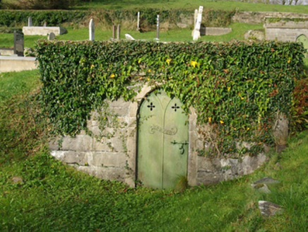
Explorer Tom Drumhome Old Church Graveyard has artistic cut stone markers and family vaults from the nineteenth century. It’s picturesque and interesting, so respect the space but snap those unique gravemarkers if you can see them clearly!

Drumhome Old ChurchChurch · 13 yd

Explorer Tom Drumhome Old Church was said in 1622 to want only a roof; after repair or possible rebuilding, it served until 1795. The old survey found just an ivy-covered west gable with a bellcote remnant. 'Only a roof' is a wonderfully bold estimate when you know how the story ends.

MurvaghOfficial bathing water · 1.1 mi

Explorer Tom Murvagh Beach has a wartime lookout hut that Joy Browne, writing for Donegal tourism, remembers playing in as a child. She says erosion has since sunk it into the sand and made entry impossible. A lookout hut retiring by burying its feet is theatrical enough for me; I would leave it to its rest.

Holy well in Ballymagrorty ScotchHoly well · 1.9 miComputer-made picture. It does not show this holy well.

Explorer Tom Holy well in Ballymagrorty Scotch is waiting for its story to be written down properly. It’s a holy well in a townland that sounds like it has plenty of local character. I bet the water there tastes like adventure, or at least it feels that way until you check the landowner.

Rooney's IslandIslet · 2.5 mi

Explorer Tom Rooney's Island was once home to the O'Maoldory Clan, who ruled as Kings of Tir Conaill. I imagine a very serious coronation ceremony taking place on a patch of ground that barely fits a picnic blanket.

RossnowlaghOfficial bathing water · 3.3 mi

Explorer Tom Rossnowlagh seems determined to be a whole journey rather than one beach. Donegal tourism runs it from Coolmore’s cliffs to Carrickfad’s rock. I would need a bigger postcard for that stretch of golden sand; the surfers have probably had that problem for years.

Salthill CabinCafé · 3.5 mi

Explorer Tom Salthill Cabin is likely just a shed with a coffee machine and delusions of grandeur. It’s in County Donegal, so expect rain to pour straight through the roof. Take a photo if you find any actual salt anywhere.

Ballyboyle IslandIslet · 3.5 mi

Explorer Tom Ballyboyle Island is named after the O'Boyles, who were sub-chieftains of the O'Donnells, which sounds like a very expensive family dinner party. Toast it with a cup of tea and move on to the next one before you get hungry.

Hawthorn3.6 mi

Explorer Tom Hawthorn in County Donegal is having a bit of a tantrum about needing permission to be seen. I'm told it's fancy stuff, but honestly, just hugging it might scare the locals off. Give it a wink for me.

Killymard Old Church GraveyardGraveyard · 4.0 mi

Explorer Tom Killymard Old Church Graveyard encloses a church whose story changes after a bleak 1622 report: it was ruinous then, was later repaired or rebuilt, and remained in use until a new church opened at Ballydevitt in 1829. The earliest modern grave slab noted in the account dates to 1809. Two timelines fit inside one walled place.

Wych Elm4.0 mi

Explorer Tom Another Wych Elm in Donegal, because apparently we can't have enough silent judges in our lives. This one seems particularly smug about being ancient and slightly damp. Tell it a joke, it's been a long time since anyone did.

Sheebarran RingfortFairy fort / earthen ringfort · 4.3 mi

Explorer Tom Sheebarran Ringfort is a massive circular space with a ditch so wide it could swallow a small car. It sits on the crest of a ridge with excellent views, making it the perfect spot for a dare to see how far you can shout. Use it as a yarn about being the king of the hill without actually wearing a crown.

More memorials and graveyards in County Donegal · All of County Donegal

Add to this placeAdd a picture Add a detailed tip Add a story

Explore the map1,118,977 places to discover

Next place · or swipeDrumhome Old Church Graveyard