
Places near here
Photo credits
- Andreas F. Borchert, Wikimedia Commons · CC BY-SA 4.0
- National Inventory of Architectural Heritage
- Kenneth Allen, Geograph · CC BY-SA 2.0
- David Dixon, Geograph · CC BY-SA 2.0
- Didier Descouens, Wikimedia Commons · CC BY-SA 4.0
- Dean Molyneaux, Geograph · CC BY-SA 2.0
- N Chadwick, Geograph · CC BY-SA 2.0
- Ronnie Nijboer, Wikimedia Commons · CC0
- louise price, Wikimedia Commons · CC BY-SA 2.0
- Jonathan Wilkins, Wikimedia Commons · CC BY-SA 2.0
 Drumhome Old ChurchChurch · 596 yd
Explorer Tom Drumhome Old Church was said in 1622 to want only a roof; after repair or possible rebuilding, it served until 1795. The old survey found just an ivy-covered west gable with a bellcote remnant. 'Only a roof' is a wonderfully bold estimate when you know how the story ends.
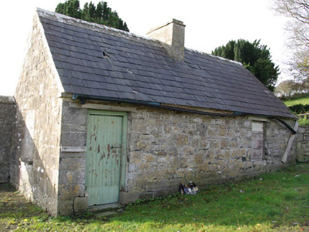 Drumhome Old Church GraveyardOutbuilding · 600 yd
Explorer Tom Drumhome Old Church Graveyard has a former sexton's house whose rear wall was built into the graveyard boundary. The little building has a ready answer: 'If you need me, I'm already in the wall.' The account dates it to around 1810 and says it is now an outbuilding.
 MurvaghOfficial bathing water · 1.4 mi
Explorer Tom Murvagh Beach has a wartime lookout hut that Joy Browne, writing for Donegal tourism, remembers playing in as a child. She says erosion has since sunk it into the sand and made entry impossible. A lookout hut retiring by burying its feet is theatrical enough for me; I would leave it to its rest.
 Rooney's IslandIslet · 2.6 mi
Explorer Tom Rooney's Island was once home to the O'Maoldory Clan, who ruled as Kings of Tir Conaill. I imagine a very serious coronation ceremony taking place on a patch of ground that barely fits a picnic blanket.
 Hawthorn3.4 mi
Explorer Tom Hawthorn in County Donegal made a New Year's resolution to grow more thorns but ended up growing way too many and now nobody can hug it properly. It’s got that prickly attitude that keeps everyone at arm's length, which is honestly quite refreshing after all the hugging. Have a chat with it, nobody's watching.
 RossnowlaghOfficial bathing water · 3.4 mi
Explorer Tom Rossnowlagh seems determined to be a whole journey rather than one beach. Donegal tourism runs it from Coolmore’s cliffs to Carrickfad’s rock. I would need a bigger postcard for that stretch of golden sand; the surfers have probably had that problem for years.
 Ballyboyle IslandIslet · 3.6 mi
Explorer Tom Ballyboyle Island in County Donegal has a New Year's resolution to stop sinking, which is ironic given it’s already halfway under the water line. It used to belong to the O’Boyles, who probably just left for better weather and never bothered checking back. Bring a coin for luck and keep it in your pocket.
 Salthill CabinCafé · 3.8 mi
Explorer Tom Salthill Cabin near Mountcharles is likely just a shed with a coffee machine and serious delusions of grandeur. It’s in Donegal, so expect rain to pour straight through the roof. Bring your worst joke, the place has heard worse.
 Wych Elm4.1 mi
Explorer Tom This second Wych Elm in County Donegal has been holding its breath for centuries, waiting to spill the beans about the pub next door. It swears it heard the landlord lose his shirt during the '98 storm and never got it back. Go on, count the windows and get it wrong like I did.
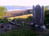 Killymard Old Church GraveyardGraveyard · 4.2 mi
Explorer Tom Killymard Old Church Graveyard encloses a church whose story changes after a bleak 1622 report: it was ruinous then, was later repaired or rebuilt, and remained in use until a new church opened at Ballydevitt in 1829. The earliest modern grave slab noted in the account dates to 1809. Two timelines fit inside one walled place.
 Sheebarran RingfortFairy fort / earthen ringfort · 4.3 mi
Explorer Tom Sheebarran Ringfort is a massive circular space with a ditch so wide it could swallow a small car. It sits on the crest of a ridge with excellent views, making it the perfect spot for a dare to see how far you can shout. Use it as a yarn about being the king of the hill without actually wearing a crown.
 Siege of DonegalSiege · 4.6 mi
Explorer Tom Siege of Donegal involved a poet who fell in the ditch nearby and wrote an entire epic about how wet his socks were while the English won, which is honestly more interesting than the strategy. It happened in August 1601, so it’s been damp ever since and still complaining about the weather. Spot the oldest stone and give it a name.
More historic places in County Donegal · All of County Donegal

What do you know about this place?Tap to add a comment or ask a question