What is recorded here
From the National Monuments Service (Archaeological Survey of Ireland) record DG094-015
Places near here
Photo credits
- D Gore, Geograph · Creative Commons Attribution-ShareAlike 2.0
- National Inventory of Architectural Heritage
- Maker not stated on source page, www.pinterest.com
- Pauloquicoli, Wikimedia Commons
- louise price, Wikimedia Commons · CC BY-SA 2.0
- Maker not stated on source page, en.wikipedia.org
- Maker not stated on source page, www.viamichelin.com
- Golfing in Ireland; photographer not stated, Source publisher
- Kenneth Allen, Geograph · CC BY-SA 2.0
- Benson Wills, Wikimedia Commons · CC BY-SA 2.0
- Thielfer, Wikimedia Commons
- louise price, Wikimedia Commons
 Thrushbank BridgeBridge · 892 yd
Explorer Tom Thrushbank Bridge spans the River Eske with two sturdy arches. I bet a local angler once mistook its shadow for a giant…
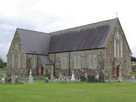 St. Agatha’s Catholic ChurchChurch/chapel · 1090 yd
Explorer Tom St. Agatha’s Catholic Church in Spierstown is sick of being asked if it’s made of real sandstone because yes, it is…
 Mapped cemeteryCemetery · 1112 yd
Explorer Tom “Mapped cemetery” in County Donegal was once ruled by a goat who thought it had the best view and wouldn’t move for…
 Ardnamona Nature ReserveNational nature reserve · 1296 yd
Explorer Tom Ardnamona Nature Reserve is the sort of oak wood that makes you lower your voice without anyone posting a sign asking…
 Drumrooske East RingfortFairy fort / earthen ringfort · 1617 yd
Explorer Tom Drumrooske East Ringfort is a large circular area with a substantial earthen bank up to two metres high, deliberately…
 Standing stoneStanding stone, pair · 1700 yd
Explorer Tom Standing stone in Clarcarricknagun is a pair, which is a rare treat for any explorer. The name sounds like it belongs…
 Lough Eske Castle HotelHotel · 1.3 mi
Explorer Tom Lough Eske Castle Hotel is five stars, so I bet the ghosts rate the view highly and complain about the WiFi. Tell it to…
 Letterkenny Golf ClubGolf course · 1.5 mi
 The Coach HousePub · 1.6 mi
Explorer Tom The Coach House in Donegal is probably full of cobwebs and old horse droppings that they call 'rural charm'. The…
 Donegal CastleCastle, tower house · 1.7 mi
Explorer Tom Donegal Castle is a massive tower house that survived being burned, demolished, and converted into a Jacobean manor.…
 The DiamondPark · 1.8 mi
Explorer Tom The Diamond is Donegal Town's grand invitation to stand in the middle of everything and pretend, briefly, that you own…
 Bluestack WayOfficial walking route · 1.8 mi
Explorer Tom The Bluestack Way begins in Donegal Town with the innocent expression of a stroll and then heads for hills, bog and…
More archaeology and monuments in County Donegal · All of County Donegal

What do you know about this place?Tap to add a comment or ask a question