
What is recorded here
Places near here
Photo credits
- National Inventory of Architectural Heritage
- Gerald England, Geograph · CC BY-SA 2.0
- Thielfer, Wikimedia Commons · CC BY-SA 4.0
- N Chadwick, Geograph · CC BY-SA 2.0
- Ian S, Geograph · CC BY-SA 2.0
- Kenneth Allen, Geograph · Creative Commons Attribution-ShareAlike 2.0
- Willie Duffin, Geograph · CC BY-SA 2.0
- Stephan van Helden, Wikimedia Commons · CC BY-SA 4.0
- louise price, Wikimedia Commons · CC BY-SA 2.0
- Becky McReynolds, Wikimedia Commons · CC BY-SA 4.0
- Andreas F. Borchert, Wikimedia Commons · CC BY-SA 4.0
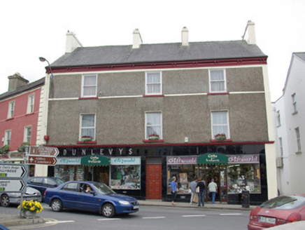 DunleavysHouse · 28 yd
Explorer Tom Dunleavys wears a coat of black Vitrolite with raised chrome lettering that looks like it just came out of a very expensive dryer. Built around 1860, it sits at the sharp corner of The Diamond, looking slightly dazed by all the shiny newness on its face.
 DonegalHistoric town · 34 yd
Explorer Tom Donegal's name means 'fort of the foreigners', but the town survey could not say whether that fort was a Viking settlement. Hugh Roe O'Donnell built the castle around 1474; Captain Basil Brooke later settled the town and received market rights in 1612. Two better-dated chapters sit beside an older unanswered name.
 Four Masters MemorialMemorial · 36 yd
Explorer Tom Four Masters Memorial puts the four annalists' names right in Donegal Town's Diamond. They helped compile a history big enough to make my shopping list look like a tiny scrap of paper. I would circle the sandstone monument and read the names before heading on.
 McCafferty’sPub · 60 yd
Explorer Tom McCafferty’s sits in The Diamond, which sounds like a gem, but I’m fairly certain the postman is suspicious of every single person who walks in there with a package. Grab a drink if you’re passing; I’m just staring at the street signs trying to find the treasure. Visit, then text me what you think. I'll pretend to read it.
 Abbey HotelHotel · 61 yd
Explorer Tom Abbey Hotel in Donegal is having a feud with the next village over something daft like whose porridge is thicker. Monks might live in the walls judging your breakfast choices. Perfect detour when the satnav has a meltdown.
 Allied Irish BankBank/financial institution · 62 yd
Explorer Tom Allied Irish Bank in Donegal is an Italianate sandstone fortress in the middle of The Diamond. It’s got cut stone detailing that makes it look like a little palace. Flash your bank card at the door, just for laughs!
 Donegal CastleVisitor information · 160 yd
Explorer Tom Donegal Castle is sitting there looking all dignified while the River Eske does its own thing nearby. It’s got history oozing out of every crack, or so they say. Go now, before it gets famous and starts charging you for the privilege of staring at it.
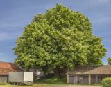 Horse-chestnut290 yd
Explorer Tom Horse-chestnut in County Donegal is just a tree with pretty cones that don’t taste great, but it looks the part. It’s standing there looking dignified while the wind tries to knock it over. Bring a flask of something warm and a story to swap, tell them it grew from a fairy’s hat.
 Donegal Railway Heritage CentreMuseum · 444 yd
Explorer Tom Donegal Railway Heritage Centre keeps the county's railway stories in an old station house, including the 1907 Drumboe engine and an interactive cab. I would begin with the engine, then try the cab to see what a driver watched. At last, a railway stop where I am allowed to stay awhile.
 Donegal Friary GraveyardGraveyard · 519 yd
Explorer Tom Donegal Friary Graveyard sits amid a place whose history changed violently in 1601, when an explosion and fire damaged the friary during a siege. The survey says later burial use raised the ground by as much as 1.75 metres. I had to read that twice: the height records generations of burial, not a building foundation.
 Siege of DonegalSiege · 659 yd
Explorer Tom The Siege of Donegal is proud that it lasted long enough for everyone to run out of tea. It’s a very specific point of pride, but valid. Bring a flask and pretend you own the whole place, because technically, you do if you hold the cup.
 Drumrooske East RingfortFairy fort / earthen ringfort · 1720 yd
Explorer Tom Drumrooske East Ringfort is a large circular area with a substantial earthen bank up to two metres high, deliberately taller on the west side. The interior has been disturbed recently, with straw rick foundations cut into the northwest bank. It sits on a drumlin summit overlooking Donegal Bay, with boggy valleys around it.
More walking routes in County Donegal · All of County Donegal

What do you know about this place?Tap to add a comment or ask a question