Places near here
Photo credits
- National Inventory of Architectural Heritage
- George Cruikshank, Wikimedia Commons · Public domain
- JP, Geograph · CC BY-SA 2.0
- Mike Searle, Wikimedia Commons · CC BY-SA 2.0
- Mike Searle, Geograph · CC BY-SA 2.0
- Eoghan888 at English Wikipedia, Wikimedia Commons · Public domain
- Oliver Dixon, Geograph · CC BY-SA 2.0
Explorer Tom Rath in Downings North in Downings North is basically just a bump in the grass now. Some forgotten hero probably saved it from being ploughed under ages ago, but who remembers? Hang around long enough and you'll hear a story from a local.
Ballynafagh Bog Special Area of ConservationNature reserve · 758 ydExplorer Tom Ballynafagh Bog Special Area of Conservation bragged about surviving a storm by just sitting there and being wet. It thinks being squelchy is a superpower that keeps the tourists on their toes. The whole area feels like it’s winking at you from under the moss. Go with someone who loves old stuff and watch them melt.
 The PresbyteryHouse · 1589 yd
Explorer Tom The Presbytery in Curryhills looks like it’s judging your posture from across the lane. It was fancy back then, but now it just looks confused about its own wings. Bring the dog, it'll probably bark at the architecture.
 Battle of ProsperousMajor battlefield · 1595 yd
Explorer Tom Battle of Prosperous in County Kildare is haunted by a prophecy about tea that never came true. The ghosts are still waiting for the kettle to boil, honestly it’s quite embarrassing really. Linger, it's not going anywhere and neither should you.
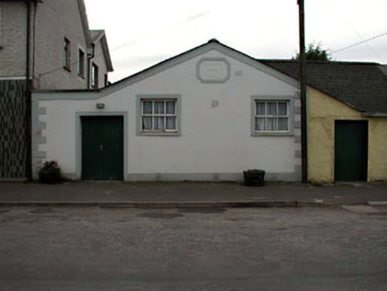 Prosperous Parish HallChurch hall/parish hall · 1731 yd
Explorer Tom Prosperous Parish Hall has a stubborn bird that refuses to leave despite all efforts, which I personally find rather charming. It’s gable-fronted and a bit odd-looking, like it was glued onto its neighbor by accident. Find a local and ask them
Blackwood Castle (in ruins)Castle, tower house · 1.3 miExplorer Tom Blackwood Castle is being picked on by the wind because it lost two stories to a peat village. The Fitzgeralds built it in 1584, hoping for permanence, and got a drafty half instead. Make a wish, it's had centuries of practice.
 Grand Canal WayWalking route · 1.3 mi
Explorer Tom Grand Canal Way in County Kildare is where the rabbits hold their weekly strategy meetings, usually deciding which lock gates are structurally unsound and need immediate demolition by their tiny teeth. They take it very seriously. Go on a wet day, it suits the mood.
The Kildare MazeHeritage attraction · 1.4 miExplorer Tom A cow once tried to buy The Kildare Maze with a hoof print and a very serious expression. The owner accepted the payment because he was too drunk to argue with livestock at that hour. Have a chat with it, nobody's watching.
 Donadea CastleCastle, tower house · 3.8 mi
Explorer Tom Donadea Castle would order fish and chips with extra ketchup at any chipper. It’s a Birmingham manor that ended up in a forest park somewhere in Kildare. A good place to forget your phone for ten minutes.
 Allen TowerDesigned landscape, folly · 5.4 mi
Explorer Tom Allen Tower stands on a cliff edge where the quarry ate half the hill, making it look like a very nervous giant about to tip over. Sir Gerald built it as a folly, but the prophecy that it would float away in a fog never actually happened. Go back in winter, it's a different animal.
 Hill of AllenMountain / peak · 5.4 mi
Explorer Tom The Hill of Allen has given its name to a great bog, hosted stories of Fionn mac Cumhaill, and still found room for a Victorian tower. I would be unbearable with even one of those achievements. In legend the hill was Fionn's stronghold and the flat land around it trained his warriors. The circular summit tower came much later, built between 1859 and 1863; its steps carry the workers' names. Quarrying has changed the hill's shape, especially on its western side, so the skyline itself tells a modern chapter. Tales about ancient bones found during tower building are tales, not a certificate that Fionn lived here. Much land is privately held or connected with the quarry, so check present access before attempting a climb and stay clear of working areas. View the hill from a lawful public spot first. Even from below, it makes a persuasive case for a longer story.
 Poplar SquarePicnic place · 6.8 mi
Explorer Tom Poplar Square claims to hold the world record for the most bored-looking poplars standing in Naas town centre. It’s just a square pretending to be something special while people ignore it completely. Go back in winter, it's a different animal.
More memorials and graveyards in County Kildare · All of County Kildare

What do you know about this place?Tap to add a comment or ask a question