What is recorded here
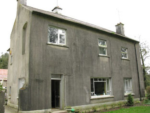
Detached three-bay two-storey house, built c.1700, having two-storey return and lean-to addition to rear (north). Pitched slate roof to main building with hipped slate roof to return, having rendered chimneystacks and cast-iron rainwater goods. Rendered walls with plinth. Square-headed window openings with rendered sills and replacement timber casement windows. Blind niche to first floor west elevation. Square-headed door opening with recent glazed timber door. Farmyard to west with single and two-storey buildings having pitched and hipped slate roofs. Corrugated-iron roof to southern block. Rubble limestone walls with roughly dressed quoins. Segmental-headed carriageway openings with dressed voussoirs to western block. Square-headed openings to northern block with remains of timber fittings. Square-profile rendered piers and splayed retaining walls to front entrance. Set within own grounds.
A complex and fascinating building, which though substantially altered, nonetheless retains much of its historic character. Possibly originally a tower house, it was modified over the centuries to accommodate changes in domestic design. The internal doors have segmental arches and the extremely thick east gable are features which indicate an early date. The first edition Ordnance Survey map of 1842 shows square-plan blocks flanking the south elevation, which no longer survive, and other alterations to the fabric suggest that the building was once substantially larger. A historical source states that it was castellated into the early nineteenth century. The house has been connected with two members of the Davis family, Dean Rowland Davis in the 1690s and James Davis in the nineteenth century. It was used as an RIC barracks in the late nineteenth century.
From the Buildings of Ireland (National Inventory of Architectural Heritage) record 20905103
This does not grant access. Most recorded buildings are privately owned; view them only from public ground unless the owner allows entry.
Places near here
 farm house1613 yd
 water pump1.2 miLyradane MountainMountain / peak · 1.6 miCastle (Site of)Castle, Anglo-Norman masonry castle · 1.9 miRock HillMountain / peak · 2.0 miCastle (Site of)Castle, unclassified · 2.4 miPairc Ath Na hEornaMemorial · 2.5 miGraveyard in KilmonaGraveyard · 3.2 mi
 New TipperaryVisitor information · 4.2 miSt John's WellSpring · 4.7 mi
 LisheenbegFairy fort / earthen ringfort · 4.7 mi
 LisheentoortaghFairy fort / earthen ringfort · 4.8 mi
Pictures: National Inventory of Architectural Heritage; Jonathan Thacker, Geograph · CC BY-SA 2.0; Tim Sheerman-Chase, Wikimedia Commons · CC BY 2.0
More historic places in County Cork · All of County Cork
What do you know about this place?