
What is recorded here
Detached four-bay single-storey over semi-basement former school, built c. 1900, with external stair to projecting gable-fronted porch to south elevation, now in use as a church hall. Pitched slate roof, with cast-iron rainwater goods. Roughcast render over random rubble stone walls. Square-headed window openings with…
Read the whole record
From the Buildings of Ireland (National Inventory of Architectural Heritage) record 40905510
Places near here
Photo credits
- Kenneth Allen, Wikimedia Commons · CC BY-SA 2.0
- National Inventory of Architectural Heritage
- Wikimedia Commons contributor · Public domain
- Ddoherty958, Wikimedia Commons · CC BY-SA 4.0
- Kenneth Allen, Geograph · CC BY-SA 2.0
- Joseph Mischyshyn, Wikimedia Commons · CC BY-SA 2.0
- Visualising Heritage, Geograph · CC BY-SA 2.0
- Keith Ruffles, Wikimedia Commons · CC BY 3.0
 Crossroads Presbyterian ChurchChurch/chapel · 34 yd
Explorer Tom Crossroads Presbyterian Church carries the date 1783 in stone on its south wall. Its survey records pierced decoration along the ridge of a later slate roof. That little crown seems keen to outshine the pointed windows while the old date stone says, 'I was here first.'
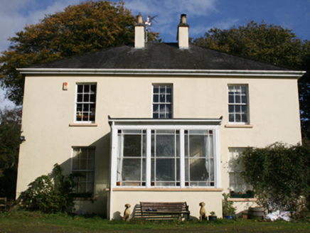 The ManseManse · 376 yd
Explorer Tom The Manse in Garshooey was built c. 1860, just as Mr. Samuel McClure settled into his role here. I reckon that projecting flat-roofed entrance porch is basically a giant, very stern umbrella for anyone arriving with muddy boots.
 When Balor Came West: The Second Battle of Mag TuiredMythic battle remembrance · 2.8 mi
Explorer Tom When Balor Came West: The Second Battle of Mag Tuired sits on flat ground below Aileach, relying entirely on Eochu Ollathair’s poem rather than archaeology. I suppose it is easier to argue with a rhyme than a shovel.
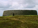 Grianán of AileachFairy fort / stone ringfort · 2.8 mi
Explorer Tom Grianán of Aileach has two roofed passages within its thick circular wall. Both curve toward the entrance and stop short. If you thought the fort was just one big ring of stone, the builders had another plan.
 Grianán of Aileach Outer HillfortHillfort · 2.8 mi
Explorer Tom Grianán of Aileach Outer Hillfort has a surprise outside the stone fort: three worn earthen rings may belong to a much older hillfort, perhaps from the Late Bronze or Iron Age. I came for one ancient place and found several piled into one hill! The long account below even traces an old road, a cairn and a holy well.
 Greenan MountainMountain / peak · 2.8 mi
Explorer Tom Greenan Mountain is a peak in County Donegal with no recorded access details. The picture looks north towards Inch Island, which makes me think the mountain is just using it as a background for its own very serious portrait.
 Coyles barPub · 3.5 mi
Explorer Tom Coyles bar in County Donegal is probably hiding a secret stash of old pints behind the tap. I bet they serve a stout that tastes like it’s been marinating in peat for decades. Grab me a pint if you’re passing through!
 Burt CastleCastle, tower house · 3.6 mi
Explorer Tom Burt Castle's roofless keep still stands on the hill, with two round corner towers and rows of gun-loops. The old account even records a spiral stair with broken steps in the south-west tower. I would admire that stubborn stonework from safe ground; those steps sound like trouble.
 Rockfield Standing StoneStanding stone · 3.9 mi
Explorer Tom Rockfield Standing Stone is over two metres tall, but the picture says cows use it like a giant scratching post! I imagine them wiggling their noses against the rock to get a proper itch gone.
 Battle of the BogsideMajor battlefield · 4.5 mi
Explorer Tom The Battle of the Bogside site has murals that tell stories louder than words ever could. One time a fox took charge of the whole situation and everyone was confused. Take a mate and argue about what it was for.
 Double BastionViewpoint · 4.5 mi
 H-Block MemorialMemorial · 4.5 mi
More historic places in County Donegal · All of County Donegal

What do you know about this place?Tap to add a comment or ask a question