What is recorded here
'Kilblaney Burial Ground' (DG022-002005-) consists of a subrectangular enclosure c. 25m E-W and c. 15m N-S defined on three sides by a wall and on the fourth by a cliff edge. Near the centre of the graveyard are three walls each c. 1m wide forming a rectangle, 4m N-S and. 5m E-W internally, open to the W end. This is…
Read the whole record
From the National Monuments Service (Archaeological Survey of Ireland) record DG022-002004
Places near here
Photo credits
- Maker not stated on source page, en.wikipedia.org
- Maker not stated on source page, www.tripadvisor.com.my
- National Inventory of Architectural Heritage
- Malcolm Neal, Wikimedia Commons
- Patrick Mackie, Geograph · CC BY-SA 2.0
- Golfing in Ireland; photographer not stated, Source publisher
- Malcolm Neal, Geograph · CC BY-SA 2.0
- Corinna Schleiffer, Wikimedia Commons · CC BY-SA 2.0
- Kenneth Allen, Wikimedia Commons · CC BY-SA 2.0
 Kilblaney Old Burial GroundGraveyard · 5 yd
Explorer Tom Kilblaney Old Burial Ground sits on a cliff edge where one side is just... water. There’s a small stone cross and a…
 Church in CarrowhughChurch · 7 yd
Explorer Tom Church in Carrowhugh may be a church or a small drystone enclosure, according to the survey. Three low walls make an…
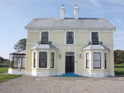 St. Michall'sHouse · 334 yd
Explorer Tom St. Michall's, built c. 1870, has wrought-iron ridge-cresting that acts as a sill-guard. I reckon those fancy iron…
 Sweet Nellie'sBeach / strand · 403 yd
Explorer Tom Sweet Nellie's is a small beach near Greencastle with a name fit for a friendly aunt and a sea quite capable of…
 White StrandBeach / strand · 414 yd
Explorer Tom White Strand near Greencastle is the sort of small Inishowen beach that lets you drive past without noticing, then…
 Carrowtrasna Burial Ground / Mass RockBurial ground · 591 yd
Explorer Tom Carrowtrasna Burial Ground / Mass Rock uses natural rock ledges as walls, saving the builders some serious effort.…
 Greencastle Golf ClubGolf course · 783 yd
 Michael John's PubPub · 880 yd
Explorer Tom Michael John's Pub has two first names, which makes it basically a committee of one. I saw a toucan on the wall, but…
 Warren LighthouseLighthouse · 911 yd
Explorer Tom Warren Lighthouse is round, its windows are square, and the light on top has several sides. For passing gulls, the…
 Inishowen LighthouseLighthouse · 1665 yd
Explorer Tom Inishowen Lighthouse began guiding ships into Lough Foyle in 1837 with twin granite towers. A local tale says a…
Stroove LighthouseLighthouse · 1667 ydExplorer Tom Stroove Lighthouse sits near Inishowen Head with beach, Lough Foyle and open sea conspiring to make its pale tower look…
 Dunagree PointHeadland · 1.1 mi
Explorer Tom Dunagree Point sits at the mouth of Lough Foyle with two old lighthouse towers keeping company and a view that makes…
More archaeology and monuments in County Donegal · All of County Donegal

What do you know about this place?Tap to add a comment or ask a question