
Places near here
Photo credits
- National Inventory of Architectural Heritage
- Golfing in Ireland; photographer not stated, Source publisher
- Patrick Mackie, Geograph · CC BY-SA 2.0
- Malcolm Neal, Geograph · CC BY-SA 2.0
- Michael Dibb, Wikimedia Commons · CC BY-SA 2.0
- Corinna Schleiffer, Wikimedia Commons · CC BY-SA 2.0
- N Chadwick, Geograph · CC BY-SA 2.0
- Kenneth Allen, Wikimedia Commons · CC BY-SA 2.0
- Rossographer, Geograph · CC BY-SA 2.0
- Matthew Chadwick, Wikimedia Commons
- N Chadwick, Wikimedia Commons · CC BY-SA 2.0
 Warren LighthouseLighthouse · 512 yd
Explorer Tom Warren Lighthouse is round, its windows are square, and the light on top has several sides. For passing gulls, the…
 Greencastle Golf ClubGolf course · 551 yd
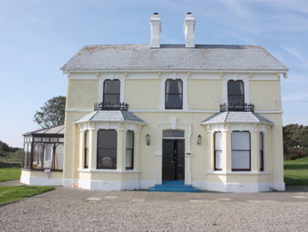 St. Michall'sHouse · 686 yd
Explorer Tom St. Michall's, built c. 1870, has wrought-iron ridge-cresting that acts as a sill-guard. I reckon those fancy iron…
 White StrandBeach / strand · 765 yd
Explorer Tom White Strand near Greencastle is the sort of small Inishowen beach that lets you drive past without noticing, then…
 Michael John's PubPub · 1266 yd
Explorer Tom Michael John's Pub has two first names, which makes it basically a committee of one. I saw a toucan on the wall, but…
 Greencastle Martello FortCastle · 1.1 mi
Explorer Tom Greencastle Martello Fort watches the narrow entrance to Lough Foyle with a low, stubborn profile that seems ready to…
 Greencastle / Northburgh CastleCastle, Anglo-Norman masonry castle · 1.2 mi
Explorer Tom Greencastle / Northburgh Castle was built by the Red Earl in 1305 to guard the shore, and it’s still standing tall on…
 StrooveOfficial bathing water · 1.3 mi
Explorer Tom Stroove Beach sits on Inishowen's eastern edge with two lighthouses keeping an eye on the sand, as if the place might…
 Dunagree PointHeadland · 1.3 mi
Explorer Tom Dunagree Point sits at the mouth of Lough Foyle with two old lighthouse towers keeping company and a view that makes…
 Martello tower on magilligan point in Doaghs LowerMartello Tower on Magilligan Point · 1.6 mi
Explorer Tom Martello tower on magilligan point in Doaghs Lower is throwing a century-old tantrum. It claims to be a fortress but…
 Inishowen Head LoopOfficial walking route · 1.7 mi
Explorer Tom Inishowen Head Loop sends you from an old lookout tower into open Donegal country, with Lough Foyle beside you and, on…
 Cliffs, Inishowen HeadPublicly named cliff or headland · 1.7 mi
Explorer Tom Cliffs, Inishowen Head are where a priest once lost a bet and had to walk home in the rain, which explains his…
More beaches and strands in County Donegal · All of County Donegal

What do you know about this place?Tap to add a comment or ask a question