
What is recorded here
From OpenStreetMap (© OpenStreetMap contributors) n3801974379
Places near here
Photo credits
- National Inventory of Architectural Heritage
- louise price, Wikimedia Commons · CC BY-SA 2.0
- louise price, Geograph · CC BY-SA 2.0
- D Gore, Geograph · CC BY-SA 2.0
- Kenneth Allen, Geograph · CC BY-SA 2.0
- Benson Wills, Wikimedia Commons · CC BY-SA 2.0
 Edergole BridgeBridge · 1.2 mi
Explorer Tom Edergole Bridge has splayed wing walls that look like it is doing a weird sideways dance. Those stone shoulders flare out as though they are avoiding the mountain stream's toes. Did it practice that move until the grass verges got bored?
 CroaghnageerMountain / peak · 1.7 mi
Explorer Tom Croaghnageer is just sitting there looking smug about it all, knowing full well we’re stuck in County Donegal for the rest of our lives. Go with someone who loves old stuff and watch them melt into puddles.
 Benson's HillMountain / peak · 1.8 mi
Explorer Tom Benson's Hill has a tiny glimpse of Lough Eske that makes it feel special and mysterious. I bet it’s hiding something big right next to that little peek of water. Snap one photo, then put the phone away and actually look.
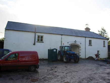 Ardnamona HouseOutbuilding · 1.9 mi
Explorer Tom Ardnamona House has a blocked pointed arch with shell mosaic around it. Why put fancy shells on a door that nobody uses? It’s like decorating a cupboard you never open. I want to know what the shell was guarding.
 Ard na Mona WoodOfficial walking route · 2.6 mi
Explorer Tom Ard na Mona Wood is an ancient oak woodland that’s seen better days but still rocks. It's a 1.9 km loop, perfect for a quick wander. Bring a coin for luck and keep it in your pocket for good measure.
 Harvey’s PointHotel · 3.2 mi
Explorer Tom Harvey’s Point has manicured lawns running straight down to the water, which sounds like a slippery slope for anyone in heels. A Swiss family started it all, so expect some weird European quirks. Tell the kids it's a castle. Close enough.
 The Ring, Leghawny Stone EnclosureEnclosure · 4.8 mi
Explorer Tom The Ring, Leghawny Stone Enclosure is soaked through and hides a seat-like stone structure called 'the Chair'. It’s not exactly comfortable, but it’s the perfect spot to watch the rain come down on Clogher Hill in absolute solitude.
 Drumrooske East RingfortFairy fort / earthen ringfort · 5.9 mi
Explorer Tom Drumrooske East Ringfort is a large circular area with a substantial earthen bank up to two metres high, deliberately taller on the west side. The interior has been disturbed recently, with straw rick foundations cut into the northwest bank. It sits on a drumlin summit overlooking Donegal Bay, with boggy valleys around it.
 Teach Tábhairne an RileánPub · 6.1 mi
Explorer Tom Teach Tábhairne an Rileán in County Donegal has a mouthful of a name. Say it three times fast for me and tell me how you feel! Bring your worst joke, the place has heard worse.
 Disert GraveyardGraveyard · 6.5 mi
Explorer Tom Disert Graveyard is a D-shaped pocket inside two larger enclosures, with at least 34 low uninscribed grave markers noted across its centre. The account also records a striking custom: people took soil from near the altar because it was reputed to drive rats from houses. I'd keep that as a belief people held, not a promise from the place.
 Donegal Railway Heritage CentreMuseum · 6.6 mi
Explorer Tom Donegal Railway Heritage Centre keeps the county's railway stories in an old station house, including the 1907 Drumboe engine and an interactive cab. I would begin with the engine, then try the cab to see what a driver watched. At last, a railway stop where I am allowed to stay awhile.
 Donegal CastleCastle, tower house · 6.8 mi
Explorer Tom Donegal Castle is a massive tower house that survived being burned, demolished, and converted into a Jacobean manor. You can still see the carved Brooke fireplace with its intricate strapwork and armorial coats of arms inside. It’s a proper architectural time capsule where history got very messy.
More mountains and hills in County Donegal · All of County Donegal

What do you know about this place?Tap to add a comment or ask a question