Places near here
Photo credits
- National Inventory of Architectural Heritage
- Peter Gerken, Wikimedia Commons · CC BY-SA 2.0
- Sheila1988, Wikimedia Commons · CC0
- Mike Searle, Geograph · CC BY-SA 2.0
- Christopher Hilton, Geograph · CC BY-SA 2.0
- Christophe Krief, Wikimedia Commons · CC BY-SA 4.0
- Pat Byrne, Geograph · Creative Commons Attribution-ShareAlike 2.0
Explorer Tom Castle in Ballycreggan was built by someone who definitely had an escape plan involving a boat. It’s a massive mound now, but you can feel the drama. If it rains, blame me, I brought the bad luck.
Embanked enclosureFairy fort / earthen ringfort · 912 ydExplorer Tom Embanked enclosure in Knocknanool would tell its younger self to stop trying so hard to be seen. It’s buried under field spoil and looking a bit embarrassed about it. It's free, it's odd, what more do you want?
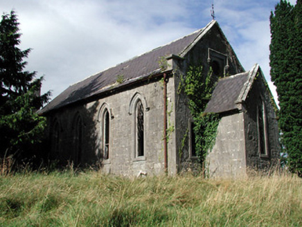 Saint Paul's Church (Kiltoom)Church/chapel · 2.2 mi
Explorer Tom Saint Paul's Church in Kiltoom is wondering what Saint Patrick would say about its bow-ended chancel, probably something rude about the roof slates being scalloped. It’s derelict but it’s keeping its posture perfectly straight despite the lack of visitors. Give the graveyard a polite nod from afar.
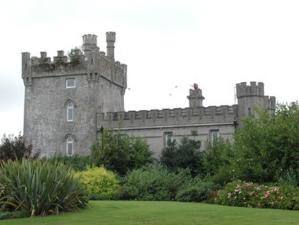 Moyvannan CastleCountry house · 2.5 mi
Explorer Tom Moyvannan Castle gave up meat for Lent but kept the crenellated parapet because it looked too good without it. It’s been a church, a fort, and now guest accommodation, which is quite the career change for a sixteenth-century tower house. If you see anyone in period costume, just assume they’re staff and not ghosts.
Bally BayBay · 3.2 miExplorer Tom Bally Bay in County Roscommon would complain to the council about how many people park their cars on the grass, which is a very specific grievance that shows it cares about aesthetics even though it’s just a body of water that doesn’t really have opinions. It’s got the energy of a nosy neighbour who knows exactly where you’ve been and thinks your boat looks ugly. If it's closed, admire
Hodson's BayBay · 3.2 miExplorer Tom Hodson’s Bay is named after a hero nobody remembers, likely because he saved it from an embarrassing stain that only God and the tide know about. The water here looks suspiciously like it’s trying to hide something behind its waves, probably a lost wallet. Find the wonkiest bit and send it to your group chat.
 Siege of AthloneSiege · 4.6 mi
Explorer Tom Another Siege of Athlone event is telling the place that replaced it to stop acting so modern, as if concrete is superior to old stone walls. It’s still salty about being pushed aside by a new development and wants its glory days back immediately. Dare you to say hello to it out loud.
 Luan GalleryGallery · 5.0 mi
Explorer Tom Luan Gallery is hiding a massive scandal from three centuries ago involving a missing hat. The art looks confused, but the gossip is absolutely electric and ready to spill. Practise your Irish on it, it won't correct you.
 Historic Town - Athlone Castle & Church of St Peter and PaulVisitor information · 5.0 mi
Explorer Tom Whoever built Athlone Castle was clearly thinking about how to make the church look good in bad weather, which is oddly specific genius. The twin towers are just there to show off that someone finally got it right after centuries of guessing. Make up your own legend and I'll swear it's true.
 CastleCastle, unclassified · 5.1 mi
Explorer Tom The Connacht Tower in Athlone was saved by a hero nobody remembers, who probably just tripped and knocked down the attackers. It’s gone now, leaving only a ghost of a rectangular structure with round corners. The land still feels like it’s holding its breath. Imagine the shape and nod slowly to yourself.
 Athlone CastleVisitor information · 5.1 mi
Explorer Tom Athlone Castle is just standing there pretending it doesn’t remember the time a goat ruled the roost and ate all the royal documents. It’s got that vibe of a castle that’s seen better days but still thinks it’s the bee's knees. Tell your mates you found it first.
 WeirWeir, fish · 5.2 mi
Explorer Tom Weir is a fish trap that has a very devoted, imaginary fan club of medieval monks who just couldn’t stop bragging about their catch. It’s basically a river obstacle course for eels with no exit strategy. Bring the dog, it'll have opinions.
More historic places in County Roscommon · All of County Roscommon

What do you know about this place?Tap to add a comment or ask a question