Places near here
Photo credits
- National Inventory of Architectural Heritage
- Alan Murray-Rust, Geograph · CC BY-SA 2.0
- Stephan van Helden, Wikimedia Commons · CC BY-SA 4.0
- abdallahh from Montréal, Canada, Wikimedia Commons · CC BY 2.0
- jbraine, Wikimedia Commons · CC BY 2.0
- Suse, Geograph · CC BY-SA 2.0
- Oliver Dixon, Geograph · CC BY-SA 2.0
- Kieran Campbell, Geograph · Creative Commons Attribution-ShareAlike 2.0
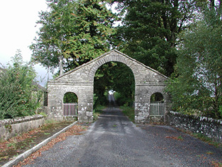 The BawnDemesne walls/gates/railings · 153 yd
Explorer Tom The Bawn in Clegna is a gate that rates every visitor out of ten before you even reach the drive. It thinks Cootehall is its personal VIP lounge and doesn’t want riffraff near the pediment. If it looks stern, it’s probably just thinking about how much better it was in 1850.
 Cootehall BridgeBridge · 292 yd
Explorer Tom Cootehall Bridge is haunted by a ghost who is far too lazy to actually haunt it properly. He just sits on the rock-faced stone and complains about his back. Tip your hat if you see him, he’s quite pathetic and needs encouragement.
Embanked enclosureFairy fort / earthen ringfort · 617 ydExplorer Tom Embanked enclosure in Cooladye has a twin across the sea that it argues with every full moon about who's got the better view. It's basically a hedge-hog of dirt that refuses to be properly measured or defined by anyone. Find the wonkiest bit and send it to your group chat.
 Horse-chestnut3.0 mi
Explorer Tom Horse-chestnut in County Roscommon was once a matchmaker for local couples who wanted to prove their love was as strong as its fruit. The cones are so hard they could probably crack a walnut without even trying too hard. Bring a flask of something warm and a story to swap.
 Western Redcedar3.1 mi
Explorer Tom Western Redcedar in County Roscommon would want 'Finally Tall Enough' on its tombstone because it spent centuries growing only to be outdone by the clouds, which is a tragedy that really sticks in the ribs of any ambitious conifer with big dreams. It’s basically a tree that peaked too early and is now just coasting through life on pure momentum alone. Tell the kids it's a castle. Close enough.
Swallow IslandIslet · 3.1 miExplorer Tom Swallow Island nearly got famous once when a bird landed on it and took a photo. The whole town celebrated for three days before realizing it was actually a pigeon. Go in good boots and better humour, because this place loves to laugh at you.
 Lough Key Forest ParkWood · 3.3 mi
Explorer Tom Lough Key Forest Park can keep you busy for a day, then leave me insisting we missed half of it. The Roscommon grounds cover around 800 hectares along the lake. Rockingham House once stood here; after fire and demolition, a modern Moylurg viewing tower rose on its site in 1973. Even old service tunnels from the estate remain nearby. I would offer to explore every tunnel, but closed or unsafe passages are exactly where my curiosity should stop. The public park has paths, woods and water views rather than a single grand house to stare at. Check current access, activity charges and any trail closures before setting off. Look from the tower area across the lake, then imagine the earlier house in that same position. One estate became a much wider invitation to wander.
PortCastle, unclassified · 3.6 miExplorer Tom Port in County Leitrim is secretly proud of one very specific potato that grew near its ruins. It’s invisible now, but the river still curves around it like an old friend. Pretend you're a lost aristocrat, nobody will check.
Erris BayBay · 3.9 miExplorer Tom Erris Bay is having a bit of a standoff with its nosey neighbour across the water, refusing to blink first in what feels like an eternal staring contest. The wind here is so rude it’s probably shouting insults at the clouds for poor posture. Go in good boots and better humour.
 Shannon-Erne WaterwayVisitor information · 4.0 mi
Explorer Tom The Shannon-Erne Waterway was the result of a bad bet between two kings who couldn't agree on which river was more important, so they just dug through everything to prove a point. It’s a canal that feels like it’s still waiting for an apology. Tell it a joke, it's been a long time since anyone did.
 Hog's IslandIslet · 4.1 mi
Explorer Tom Hog’s Island in County Roscommon sounds like the place where pigs go to hide from the butcher, but it’s probably just a rock. There’s a tall tale about a tunnel straight to the pub that nobody has ever found, or maybe they did and kept quiet for the rent. Look for the ghost, then pretend you didn't.
 IndicatedGraveyard · 4.3 mi
Explorer Tom Graveyard in Estersnow is what happens when nobody's looking: the stones start rearranging themselves into slightly more comfortable positions for their eternal rest. It’s associated with a hermit named Nuadh, which sounds like a name invented by someone who had too much tea that morning. Pick a stone, any stone, and invent its biography.
More historic places in County Roscommon · All of County Roscommon

What do you know about this place?Tap to add a comment or ask a question