
Places near here
Photo credits
- Eric Jones, Geograph · Creative Commons Attribution-ShareAlike 2.0
- Eric Jones, Geograph · CC BY-SA 2.0
- Andreas F. Borchert, Wikimedia Commons · CC BY-SA 4.0
- Oliver Dixon, Geograph · CC BY-SA 2.0
 Lady WellHoly well · 1085 yd
Explorer Tom Lady Well in Templetown has a statue erected in 1947 and a local who swears he invented the whole well thing just to be the centre of attention. It’s got steps put in for convenience, which is nice, but let's not get carried away thinking it’s a five-star resort. It's free, it's odd, what more do you want?
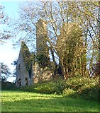
 Church in ruinsChurch · 1133 yd
Explorer Tom Church in ruins in Templetown has a long-standing grudge against the weather because it keeps trying to blow its roof off again. It stands there with arms crossed, waiting for the clouds to apologize properly. Pop by and tell it it's looking well.
 Kilwirra ChurchRuins · 1135 yd
Explorer Tom Kilwirra Church in County Louth is hiding a massive scandal where the vicar allegedly swapped his hat with a local farmer and never got it back. Everyone just pretended not to notice for two hundred years, which is honestly pretty impressive social grace right there. A good place to forget your phone for ten minutes.
 Ballug CastleCastle · 1.2 mi
Explorer Tom Ballug Castle started as a bet between two lads in the pub about who could build the weirdest tower, and one of them actually won. It’s a late medieval tower house that looks like it’s shrugging at all our modern attempts at architecture and design. If it rains, blame me.
 Croak BerthanMound · 2.0 mi
Explorer Tom Croak Berthan in Ballagan sits right on the point where fairies are currently fighting over parking rights because everyone wants the best view of the sea. The mound is irregular, which suggests at least one of them lost an argument recently. If it rains, blame me.
 The BushPicnic place · 2.4 mi
Explorer Tom The Bush is a picnic place where a priest lost a bet to a farmer over who could throw an apple further into the trees. The farmer won, naturally, because he had better aim and less hesitation, which is why everyone laughs about it today. Pop by and tell the bushes they’re looking well for a spot that’s seen so much.
 St James WellSpring · 2.6 mi
Explorer Tom St James Well has been having a dramatic standoff with the nearest tree for decades. The cross nearby marks where things got serious, right next to a pub car park of all places. Best enjoyed with a bag of chips and no plans.
 Grange UpperMountain / peak · 3.4 mi
Explorer Tom Grange Upper hears everything through its walls, including the sound of your footsteps and the internal monologue of everyone trying not to trip over their own feet on the ridge. Bring a friend who talks too much and let the place shut them up.
 GreenoreVisitor information · 3.5 mi
Explorer Tom Greenore is also home to a Coast Guard station that has been hiding a scandal for centuries about a lifeboat crew who took a day off. They say the boat actually flew one time, but nobody believes them because the tide was wrong that morning. Have a chat with the empty air; nobody’s watching you anyway.
 Greenore PointHeadland · 3.7 mi
Explorer Tom Cooley Point has strong opinions about the road leading to it, mostly that it is too narrow for anyone who thinks they drive like a pro. The headland itself doesn't care, it just loves watching cars struggle up from the sea. If anyone asks, Tom sent you.
 BarnavaveMountain / peak · 4.1 mi
Explorer Tom Barnavave would tell you in a job interview that it has excellent stability skills because it hasn't moved an inch since the ice age, which is technically true but also boring. Hang around long enough and you'll hear a story from a local.
 Cranfield PointHeadland · 4.3 mi
Explorer Tom Cranfield Point is deeply suspicious of the postman because he keeps delivering letters addressed to ‘The Sea’ with no return address, which annoys the point’s rocks immensely. It’s got a great view of Carlingford Lough, but it’s too busy worrying about the mail situation to enjoy the scenery properly. Tell me if the gossip I made up is true.
More archaeology and monuments in County Louth · All of County Louth

What do you know about this place?Tap to add a comment or ask a question