Places near here
Photo credits
- Cg.wiki, Wikimedia Commons · CC BY-SA 4.0
- National Inventory of Architectural Heritage
- Mike Searle, Wikimedia Commons · CC BY-SA 2.0
- Peter Gerken, Geograph · CC BY-SA 2.0
- JP, Wikimedia Commons · CC BY-SA 2.0
 Church (in ruins)Church · 8 yd
Explorer Tom Corrstown Church has only its west tower base left, which is like showing up to a party with just your shoes on. It was built of limestone blocks and has a spiral stair, so it’s basically a very old fitness center. Bring the dog, it'll have opinions.
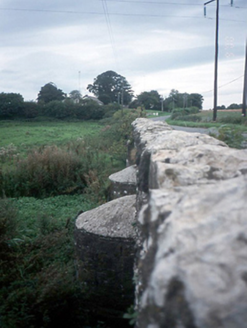 Chapelmidway BridgeBridge · 201 yd
Explorer Tom Chapelmidway Bridge in Corrstown is three arches old enough to vote and probably still thinks about that bet two lads made in the pub that started it all. Practise your Irish on it, it won't correct you.
Freedagh MoatCastle, motte · 870 ydExplorer Tom Freedagh Moat is sitting on a ridge where the weather has a long grudge against it, keeping it damp and grumpy. Find a local and ask them the real story, then come back and tell me if they sound sane.
 CastleCastle, tower house · 2.0 mi
Explorer Tom Castle in Dunsoghly is surrounded by seagulls who are constantly critiquing its four corner towers for not having enough character. Bring a map, get lost anyway, that's the fun, especially when you’re staring at wicker-work centring and pretending it’s art.
Graveyard in KillosseryGraveyard · 2.3 miExplorer Tom Graveyard in Killossery looks like it was built on top of something older, raised two metres above the ground. Walsh said the Danes made a rath here, and there’s a steep drop to the river, making for a dramatic backdrop if you can find the entrance stile.
 IndicatedFish-pond · 2.5 mi
Explorer Tom Fish-pond in Brackenstown is actually a canal from the early eighteenth century, which is a bit cheeky of them to call it a pond. It’s used for horse riding now, so watch out for hooves and muddy boots.
Horizon Logistics ParkVisitor information · 2.6 miExplorer Tom Horizon Logistics Park is basically a giant box warehouse with delusions of grandeur. I’m sure the forklifts are very charming company.
St Cronans WellSpring · 2.8 miExplorer Tom St Cronans Well in County Dublin has a church complex that looks like it’s about to collapse into the earth. The saint probably just wanted a quiet spot to nap. Keep an eye out for any suspiciously holy ducks!
 Glasmore Abbey (in ruins)Structure · 2.9 mi
Explorer Tom Glasmore Abbey is a square, enigmatic building with medieval insertions that survives to one storey height. It looks like a box made of limestone blocks in Mooretown. Bring curiosity, leave with a better story than mine about its purpose.
The JackoWood · 2.9 miExplorer Tom The Jacko in County Dublin is under a mill arch. Sounds industrial and chic. Like a wood that went to art school. Very pretentious, I think.
 BallymunVisitor information · 4.2 mi
Explorer Tom Ballymun in County Dublin is doing some serious redevelopment, mostly by turning office blocks into things that look like office blocks. It's a deprived part of Dublin, so bring a scarf for luck.
 Dunsink ObservatoryHeritage attraction · 4.9 mi
Explorer Tom Dunsink Observatory has been staring at the stars since 1783 and getting absolutely no replies. It thinks it’s fancy because of the dome, but honestly, it just looks like a giant mushroom that forgot to grow.
More memorials and graveyards in County Dublin · All of County Dublin

What do you know about this place?Tap to add a comment or ask a question