
Places near here
Photo credits
- National Inventory of Architectural Heritage
- Aiden Clarke, Wikimedia Commons · CC BY-SA 2.0
Explorer Tom Cashel in County Roscommon has a priest who lost a bet about how tall the hill actually was. The rocks are still arguing about it, but nobody wants to admit they measured with their toes. Bring curiosity, leave with a better story than mine.
CastleBawn · 1.2 miExplorer Tom Castle Dower has a superstition that if you don't wave properly, your socks will turn inside out for a week, which locals swear is true. It was burned in fifteen twenty-seven and has been grumpy about it ever since then. Stand where the owner stood and practise looking smug.
Bawn IslandIslet · 1.4 miExplorer Tom Bawn Island started because two lads in the pub bet fifty quid they could name it and get away with it. They lost badly, but the name stuck because nobody else wanted to deal with the paperwork. Go back in winter, it’s a completely different animal.
Square WoodForest · 1.7 miExplorer Tom Square Wood in County Roscommon looks like it was drawn with a ruler and some very angry geometry chalk. Rumor has it a fox took charge last spring and forced everyone to walk in perfect parallel lines. Bring someone who'll believe anything.
 Frenchpark HouseBuilding misc · 1.8 mi
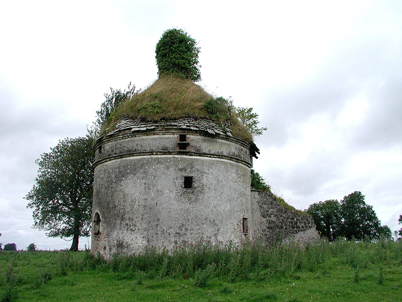
Explorer Tom Frenchpark House is a circular smokehouse with stone slates, looking like a fancy mushroom that got lost on the way to a tea party. It's probably jealous of Blarney Castle and wants a turn at the kissing stone. Keep your eyes peeled for any suspiciously round bricks lying around.
Frenchpark HouseCastle, unclassified · 1.8 miExplorer Tom Frenchpark House is hiding a secret message in its stones, probably about who owes whom a drink. The MacDermots built it, but the stones seem to whisper about better days gone by. Look up, the best bit is always higher than you think.
Gray's WoodForest · 1.9 miExplorer Tom Gray's Wood in County Roscommon is in the middle of a furious dispute with a fairy over parking rights for her tiny little silver chariot lately. She’s blocking the path with her wings and he’s getting quite cross about it all, to be perfectly honest with you here. Spot the oldest stone and give it a name.
 Saint Baoithín's Catholic ChurchChurch/chapel · 2.3 mi
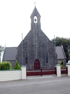
Explorer Tom Saint Baoithín’s Church is guarded by a dog named Kevin who only answers to the name “Pope” and refuses to let anyone near the stained glass. The rock-faced limestone looks like it’s been through a few bad hair days, but it’s still showing off its symmetry. Pet Kevin if you dare.
Rose PointHeadland · 3.0 miExplorer Tom Rose Point in County Sligo had the whole parish arguing about it last Tuesday, mostly over who owned the view. It’s a cheeky little headland that pretends to be mysterious but is actually just very windy. A good place to forget your phone for ten minutes and enjoy the silence.
Castle PointHeadland · 3.7 miExplorer Tom Castle Point in County Sligo is currently embroiled in a fairy dispute over parking rights, with tiny wings buzzing angrily around the lighthouse foundation. They’ve drawn lines in the sand that definitely weren’t there yesterday and are very upset about boundary violations. Find the wonkiest bit and send it to your group chat.
Fairymount HillMountain / peak · 3.9 miExplorer Tom Fairymount Hill has been hiding a scandal about a fairy who lost her purse and blamed a local farmer for the theft. She’s been sulking in the hollows ever since, refusing to come out because she’s too embarrassed to admit it was her own fault. It’s a secret that’s kept the air up there smelling slightly of damp wool and regret for centuries. Go before the tourists find out.
 ToberaraghtHoly well · 3.9 mi
Explorer Tom Toberaraght in Clogher has cursing stones cemented on top like very angry bookmarks. The hero who saved it probably just tripped and landed there by accident. Grand place for a sulk or a snog, entirely your call.
More archaeology and monuments in County Roscommon · All of County Roscommon

What do you know about this place?Tap to add a comment or ask a question