
Places near here
Photo credits
- Kieran Campbell, Geograph · CC BY-SA 2.0
- National Inventory of Architectural Heritage
- Sitomon, Wikimedia Commons · CC BY-SA 2.0
- Albert Bridge, Geograph · CC BY-SA 2.0
- Aubrey Martin, Wikimedia Commons · CC BY-SA 4.0
- Olivier BEZES, Wikimedia Commons · CC BY 2.5
- Wanfried-Dublin, Wikimedia Commons · CC BY-SA 4.0
- 瑞丽江的河水, Wikimedia Commons · CC BY-SA 4.0
- Rob Hurson, Wikimedia Commons · CC BY-SA 4.0
 Old ChurchChurch · 227 yd
Explorer Tom Old Church in Kilberry was once tried to be bought by a very determined cow. Only low walls remain now, but the dedication to St John is still standing strong. Tell the next person you meet it's haunted. It might be.
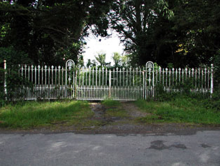 gates/railings/walls1.7 mi
Explorer Tom Gates in Wilkinstown are showing off their fancy cast-iron anthemions like they’re at a fancy dress party. They look incredibly sharp and definitely want you to know that a skilled craftsman worked hard on them. It’s like an imposing entrance that just won’t shut up about its fleur-de-lis details. Keep your distance while you admire the intricate metalwork.
Mullagha HillMountain / peak · 2.0 miExplorer Tom Mullagha Hill swears by a superstition where you have to lick a rock before touching the grass to avoid bad luck. I’m pretty sure that was made up by someone who needed an excuse for having sticky fingers. It’s a hill with too many rules and not enough sense of humour. Bring a friend who talks too much and let the place shut them up.
 European Yew2.5 mi
Explorer Tom Local legend says a giant hid inside this European Yew to avoid paying rent, and he’s still in there somewhere. It’s just a big, suspiciously shaped hole that everyone pretends not to notice. Bring a map, get lost anyway, that's the fun.
 Round Tower2.8 mi
Explorer Tom Round Tower in Donaghmore has a long-standing grudge against the wind, which keeps trying to blow it over. It’s survived centuries, so let the clouds have their moment. Tell it a joke, it's been a long time since anyone did.
 Donaghmore Round TowerHeritage attraction · 2.8 mi
Explorer Tom Donaghmore Round Tower in County Meath is probably the favourite hangout for local rabbits who use it as their main lookout point for danger. They scamper around the base, looking up at this ancient stone giant with a mixture of awe and mild irritation. It’s basically their personal tower of power without them knowing it. Snap one photo, then put the phone away and actually look.
Nangle CourtMemorial · 3.1 miExplorer Tom Nangle Court in County Meath was haunted by a fiddler who played all night long until the windows rattled off their hinges and dropped into the mud. He never stopped, even when the moon tried to distract him with its glow. The music is still faintly audible if you hold your breath. Bring a flask and pretend you own the place.
 Lebanon Cedar3.7 mi
Explorer Tom This Lebanon Cedar has an ongoing feud with the rain, complaining that it gets in its hair too much. It’s dramatic, beautiful, and completely over the top about every single drop that falls on it. Go on a wet day, it suits the mood.
 Druids AltarPortal tomb · 3.8 mi
Explorer Tom Druids Altar in Rathkenny hosted a fiddler who played all night without stopping. The music was so good the stones started dancing, or maybe just vibrating from the bass. Give it a pat on the way past, it's had a long life.
Simpson's MountainMountain / peak · 3.8 miExplorer Tom Simpson's Mountain would order a full chipper with triple vinegar if it went to the pub tonight. It probably thinks its rocky texture is a fashion statement that no one else is copying. I bet it’s been waiting for someone to notice its unique geological vibe. Pick a stone, any stone, and invent its biography.
 Athlumney CastleCastle, tower house · 4.1 mi
Explorer Tom Athlumney Castle is hiding a treasure chest that is definitely just an old biscuit tin from 1974, but don't tell the locals. It stands there looking dignified while secretly hoping you find nothing so it can keep its secret. Bring a flask and pretend you own the place.
 CastleCastle, motte · 4.1 mi
Explorer Tom This motte in Athlumney is jealous of the actual castle next door because nobody takes photos of it on purpose. It’s just a big dirt cone that dreams of having a roof one day. Stand on the spot and imagine the gossip it's heard from the river.
More archaeology and monuments in County Meath · All of County Meath

What do you know about this place?Tap to add a comment or ask a question