
What is recorded here
Internal diam. c. 25m. A subcircular area now enclosed by a much collapsed stone wall. Pieces of wall-facing are visible but not sufficiently to calculate the wall width. The interior is overgrown and stone-covered with field clearance and parts of the wall have been quarried away. It is situated on good farmland…
Read the whole record
From the National Monuments Service (Archaeological Survey of Ireland) record DG052-027
Places near here
Photo credits
- Maker not stated on source page, www.pinterest.com
- Kenneth Allen, Geograph · Creative Commons Attribution-ShareAlike 2.0
- National Inventory of Architectural Heritage
- Geraldine Diver / Donegal Daily, www.donegaldaily.com
- Maker not stated on source page, commons.wikimedia.org
- Maker not stated on source page, www.kobo.com
- Maker not stated on source page, www.britainexpress.com
- Kenneth Allen, Wikimedia Commons · CC BY-SA 2.0
- Maker not stated on source page, www.tripadvisor.ca
- Kenneth Allen, Geograph · CC BY-SA 2.0
 Former Kilpheak Enclosure near St Columba's ChurchEnclosure · 622 yd
Explorer Tom Former Kilpheak Enclosure near St Columba's Church is playing the great disappearing act. The maps from the first and…
 Saint Columba's Catholic ChurchChurch/chapel · 671 yd
Explorer Tom Saint Columba's Catholic Church in Kilpheak has no windows on the front wall, so it’s basically staring into space with…
 Fox HallWalled garden · 799 yd
Explorer Tom Fox Hall's walled garden was laid out around 1860 with rubble stone walls and a red-brick arch over its south entrance.…
 Rashedoge BridgeBridge · 1327 yd
Explorer Tom Rashedoge Bridge humps its one stone arch over the River Swilly, carrying a laneway on top. Built around 1800, it has…
 Páirc Naomh Columba, GlenswillyGAA ground · 1338 yd
 Standing stone in Doon GlebeStanding stone · 1.0 mi
Explorer Tom This Standing stone in Doon Glebe is officially gone, leaving behind just a subcircular hole and some weird rope. It…
 Standing stone in DrumanaughtStanding stone · 1.5 mi
Explorer Tom The Standing stone in Drumanaught was nearly sold to a farmer as a really expensive horse trough before anyone realized…
 Standing stone in DrumnahoughStanding stone · 1.8 mi
Explorer Tom Standing stone in Drumnahough has vanished completely! The map says it was there, but now there’s just… grass? Maybe it…
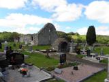 Stackarnagh Abbey GraveyardGraveyard · 1.9 mi
Explorer Tom Stackarnagh Abbey Graveyard has a gatepost detail I keep coming back to: a reused window fragment carved with a fish…
 Templedouglas CemeteryGraveyard · 1.9 mi
Explorer Tom Templedouglas Cemetery in County Donegal is playing hide-and-seek with me. A tale from 1846 says an earl built it, but…
 Gregory HillMountain / peak · 2.0 mi
Explorer Tom Gregory Hill stands in County Donegal, keeping its access details firmly unknown. The name sounds like a word you’d…
 Cabra Glebe Earthen RingfortFairy fort / earthen ringfort · 2.0 mi
Explorer Tom Cabra Glebe Earthen Ringfort has a ledge running right next to its bank, which is weirdly specific for an old farm. The…
More archaeology and monuments in County Donegal · All of County Donegal

What do you know about this place?Tap to add a comment or ask a question