
What is recorded here
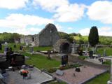
Internal diam. c. 34m. A subcircular area enclosed by an earthen bank containing some stones surviving up to 1.25m in height in places but in others it is almost level with the interior. Just inside the bank is a ledge of earth c. 0.1m to .15m in height and c. 1.5m wide. It is particularly noticeable on the W and N…
Read the whole record
From the National Monuments Service (Archaeological Survey of Ireland) record DG052-016
Places near here
Photo credits
- Kenneth Allen, Wikimedia Commons · CC BY-SA 2.0
- Maker not stated on source page, www.tripadvisor.ca
- National Inventory of Architectural Heritage
- Maker not stated on source page, ru.pinterest.com
- Dr Neil Clifton, Geograph · CC BY-SA 2.0
- Dr Neil Clifton, Geograph · Creative Commons Attribution-ShareAlike 2.0
- Maker not stated on source page, commons.wikimedia.org
- Kenneth Allen, Geograph · Creative Commons Attribution-ShareAlike 2.0
- Geraldine Diver / Donegal Daily, www.donegaldaily.com
- Maker not stated on source page, uk.pinterest.com
 Stackarnagh Abbey GraveyardGraveyard · 996 yd
Explorer Tom Stackarnagh Abbey Graveyard has a gatepost detail I keep coming back to: a reused window fragment carved with a fish…
 Templedouglas CemeteryGraveyard · 996 yd
Explorer Tom Templedouglas Cemetery in County Donegal is playing hide-and-seek with me. A tale from 1846 says an earl built it, but…
 Cabra BridgeBridge · 1.0 mi
Explorer Tom Cabra Bridge crosses the Leannan River on three arches, built around 1860; one arch remains from a bridge dating around…
 Man-made underground passage in Keeloges (church Hill Ed)Man-made underground passage · 1.0 mi
Explorer Tom Man-made underground passage in Keeloges rests on Kinahan's 1887 mention of an artificial cave on Leafin Hill. Later…
 Man-made underground passage in Church HillMan-made underground passage · 1.5 mi
Explorer Tom Man-made underground passage in Church Hill was a drystone box buried beneath the earth, recorded back in 1953. Sadly…
 Church Hill Post OfficeHouse · 1.6 mi
Explorer Tom Church Hill Post Office was built around 1830 as part of a nine-bay block. Two bays belonged to the post office and…
 Wilkin's of Church HillPub · 1.6 mi
Explorer Tom Wilkin's of Church Hill in County Donegal sounds like it's guarded by an angel who demands tips for listening to your…
 Saint Columba's Church (Gartan)Church/chapel · 1.6 mi
Explorer Tom Saint Columba's Church in Gartan bragged about surviving a storm so bad it blew its own roof off, then had to pay for a…
 Standing stone in SockarStanding stone · 1.7 mi
Explorer Tom Standing stone in Sockar is a pair of stones that Kinahan noted back in the late 1800s. They’ve both vanished from the…
 Saint Columba's Catholic ChurchChurch/chapel · 1.8 mi
Explorer Tom Saint Columba's Catholic Church in Kilpheak has no windows on the front wall, so it’s basically staring into space with…
 Páirc Naomh Columba, GlenswillyGAA ground · 2.3 mi
 Gallagher's IsleIslet · 2.3 mi
Explorer Tom Gallagher's Isle is telling the new development next door that it was here first and has better stories to tell. It’s…
More archaeology and monuments in County Donegal · All of County Donegal

What do you know about this place?Tap to add a comment or ask a question