
What is recorded here
From OpenStreetMap (© OpenStreetMap contributors) n4125594511
Places near here
Picture notes
- netwhizkid, Wikimedia Commons · CC BY 2.0
- Computer-made picture. It does not show this monument.
- Computer-made picture. It does not show this mountain top.
- Computer-made picture. It does not show this walking route.
- National Inventory of Architectural Heritage
- Computer-made picture. It does not show this playground.
 MullaghanishMountain / peak · 1237 yd
Explorer Tom Mullaghanish has caught my eye in County Cork. I bet a mountain / peak with a name like that could keep me talking all afternoon; I'm already inventing a daft little scene for it, and I'll stop before it turns into history.
 Hut site in CummeennabuddogeHut site · 1658 ydComputer-made picture
Explorer Tom Hut site in Cummeennabuddoge would introduce itself as 'I’m fancy' while sitting in a boggy forest. It’s a rectangular box pretending to be a palace, surrounded by trees that judge its architecture. Look up, the best bit is always higher than you think.
 LackabaunMountain / peak · 1.7 miComputer-made picture
Explorer Tom Lackabaun has caught my eye in County Cork. I bet a mountain / peak with a name like that could keep me talking all afternoon; I'm already inventing a daft little scene for it, and I'll stop before it turns into history.
 Sli Gaeltacht MuscraiWalking route · 1.9 miComputer-made picture
Explorer Tom Sli Gaeltacht Muscrai has caught my eye in County Kerry. I bet a walking route with a name like that could keep me talking all afternoon; I'm already inventing a daft little scene for it, and I'll stop before it turns into history.
 Fairy fort / earthen ringfort in Gleann DaimhFairy fort / earthen ringfort · 1.9 miComputer-made picture
Explorer Tom Fairy fort / earthen ringfort in Gleann Daimh is sheltered by rock outcrops and has a culvert running through it, which is very practical for ancient times. The outer stone facing is mostly collapsed, so the vibes are a bit tattered but charmingly so. Best visited with a curious kid and no timetable.
 GallánStanding stone · 1.9 miComputer-made picture
Explorer Tom Gallán in Na Huláin Thiar has packing stones at its base, which means someone cared about it staying up. One-point-six-six metres tall and not on the old maps. It’s been hiding in plain sight in the rough grazing.
 Megalithic tomb in An Cheapach ThoirMegalithic tomb · 1.9 miComputer-made picture
Explorer Tom Megalithic tomb in An Cheapach Thoir looks like someone left six stones standing in three lines and forgot about them. No table stone remains, just the skeleton of a cromleac. Perfect spot to practise your best tour-guide voice for the empty audience.
 Fairy fort / earthen ringfort in Na Huláin ThoirFairy fort / earthen ringfort · 1.9 miComputer-made picture
Explorer Tom Fairy fort / earthen ringfort in Na Huláin Thoir sits next to a stream with gaps in the bank to the north and east. Field clearance stones are dumped everywhere, so it looks like a giant’s messy bedroom. I’d say it needs a serious tidy-up session.
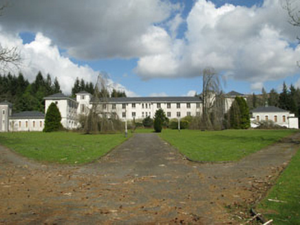 Coláiste ÍosagáinSchool · 2.6 mi
Explorer Tom Coláiste Íosagáin in Slievereagh was built to teach Irish, which I’m sure went down a treat with the locals. It’s a proper boarding school setup from the 1930s. Listen for echoes of old arguments in those stair towers.
 Gairdín GhobnatanChildren's playground · 2.8 miComputer-made picture
Explorer Tom Gairdín Ghobnatan has caught my eye in County Cork. I bet a children's playground with a name like that could keep me talking all afternoon; I'm already inventing a daft little scene for it, and I'll stop before it turns into history.
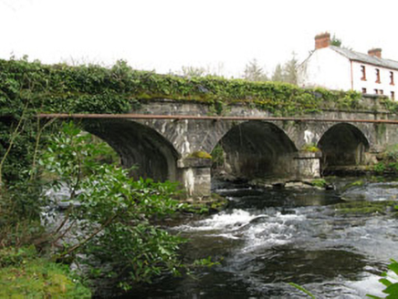 bridge2.8 mi
Explorer Tom Bridge in Gortnatubbrid has three arches because one wasn’t enough. Built in 1830, it’s been carrying traffic since before my great-great-grandma existed. Hop on top of a rock and strike a pose for the river!
 Blackwater (Duhallow) WayWalking route · 5.8 miComputer-made picture
Explorer Tom Blackwater (Duhallow) Way has caught my eye in County Kerry. I bet a walking route with a name like that could keep me talking all afternoon; I'm already inventing a daft little scene for it, and I'll stop before it turns into history.
More mountains and hills in County Cork · All of County Cork

What do you know about this place?Tap to add a comment or ask a question