
What is recorded here
From the National Monuments Service (Archaeological Survey of Ireland) record LH008-063
Places near here
Photo credits
- Eric Jones, Geograph · CC BY-SA 2.0
- Maker not stated on source page, commons.wikimedia.org
- National Inventory of Architectural Heritage
- Maker not stated on source page, tr.pinterest.com
- Maker not stated on source page, irisharchaeology.org
- Kmcnamee, Wikimedia Commons · CC BY-SA 4.0
- Garry Dickinson, Geograph · CC BY-SA 2.0
 Saint James's Catholic ChurchChurch/chapel · 666 yd
Explorer Tom Saint James's Church in Grange Irish took about four thousand cups of tea to build, I reckon. It’s one of the oldest…
 Mapped cemeteryCemetery · 674 yd
Explorer Tom Mapped cemetery in County Louth is occupied by one specific bird that refuses to leave no matter how much you shoo it…
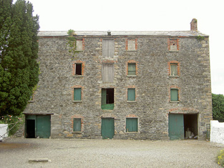 granary730 yd
Explorer Tom Granary in Monksland has a retirement plan that involves turning into a trendy coffee shop with very expensive lattes…
 Megalithic StructuresMegalithic tomb · 832 yd
Explorer Tom Megalithic Structures in Grange Irish got demolished by a guy who thought he was clearing weeds for the garden party of…
 Fairy fort / earthen ringfort in Rath LowerFairy fort / earthen ringfort · 902 yd
Explorer Tom Rath Lower is in a bitter rivalry with every other famous fort because it’s got 'Lower' in its name. It’s a scarped…
 Fr. Mc Evoy Park, Cooley KickhamsGAA ground · 1016 yd
 Grange UpperMountain / peak · 1647 yd
Explorer Tom Grange Upper hears everything through its walls, including the sound of your footsteps and the internal monologue of…
 The BushPicnic place · 1.2 mi
Explorer Tom The Bush is a picnic place where a priest lost a bet to a farmer over who could throw an apple further into the trees.…
 BarnavaveMountain / peak · 1.3 mi
Explorer Tom Barnavave would tell you in a job interview that it has excellent stability skills because it hasn't moved an inch…
 Carlingford - Loop 1A- Commons LoopWalking route · 1.7 mi
Explorer Tom Carlingford - Loop 1A- Commons Loop in County Louth would survive a zombie attack by hiding behind its overgrown bushes…
 Carlingford Heritage CentreVisitor information · 1.8 mi
Explorer Tom Carlingford Heritage Centre occupies the old Church of the Holy Trinity, which has spent centuries watching this County…
 CastleCastle, tower house · 1.8 mi
Explorer Tom Castle in Liberties of Carlingford bragged it survived a massive storm, but honestly, it looks like it just dodged one.…
More archaeology and monuments in County Louth · All of County Louth

What do you know about this place?Tap to add a comment or ask a question