
What is recorded here
From the National Monuments Service (Archaeological Survey of Ireland) record ME038-017001
Places near here
Photo credits
- Maker not stated on source page, veri-art.net
- Maker not stated on source page, www.youtube.com
- Maker not stated on source page, commons.wikimedia.org
- Golfing in Ireland; photographer not stated, Source publisher
- Maker not stated on source page, en.wikipedia.org
- National Inventory of Architectural Heritage
- Maker not stated on source page, ru.pinterest.com
- Garry Dickinson, Geograph · CC BY-SA 2.0
 Church (in Ruins)Church · 7 yd
Explorer Tom Church in Trevet claims it’s older than your great-grandfather's bad haircuts, which is bold for a place with no walls…
 TombTomb, chest tomb · 15 yd
Explorer Tom Tomb in Trevet looks like it would wear a tuxedo and drink too much champagne at a wedding. Sir Thomas Cusack is buried…
 Earthwork in Trevet GrangeEarthwork · 1209 yd
Explorer Tom Earthwork in Trevet Grange is a small mound that thinks it’s a moat because an old map said so back in 1836. There was…
 Black Bush Golf ClubGolf course · 1.1 mi
 Enclosure in Roestown (ratoath By.)Enclosure · 1.3 mi
Explorer Tom There is a dog in charge here that has never met a fence it didn't want to inspect personally before allowing anyone…
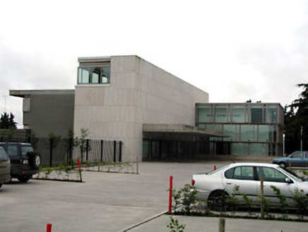 Dunshaughlin Civic OfficesOffice · 1.9 mi
Explorer Tom Dunshaughlin Civic Offices in Dunshaughlin thinks it’s too cool to need heating or cooling, which is bold for an office…
 Earthwork in ColvinstownEarthwork · 1.9 mi
Explorer Tom Earthwork in Colvinstown has the weather's long grudge against it, as it vanished after appearing on an 1826 map. It’s…
 outbuilding2.0 mi
Explorer Tom Outbuilding in Dunshaughlin is the last survivor of an industrial complex that used to be all the rage. It’s got brick…
 Fairy fort / earthen ringfort in Collierstown (skreen By.)Fairy fort / earthen ringfort · 2.1 mi
Explorer Tom This Collierstown ringfort really hates when visitors trip over its own banks, which are surprisingly soft for being…
Enclosure in Flemingtown (ratoath By.)Enclosure · 2.2 miExplorer Tom Enclosure in Flemingtown is basically a grid of tiny plots that look like someone tried to draw a city map but got…
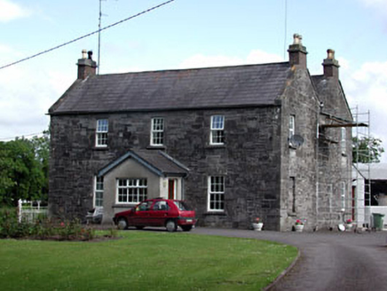 Oberstown HouseFarm house · 2.6 mi
Explorer Tom Oberstown House in County Meath mixes limestone and brick like it’s showing off. Its first owner planned to escape by…
 Skreen CastleCastle, tower house · 3.0 mi
Explorer Tom Skreen Castle is overhearing every secret the walls have swallowed over the centuries and judging your life choices…
More archaeology and monuments in County Meath · All of County Meath

What do you know about this place?Tap to add a comment or ask a question