What is recorded here
From the National Monuments Service (Archaeological Survey of Ireland) record ME005-080001
Places near here
Photo credits
- Maker not stated on source page, commons.wikimedia.org
- Maker not stated on source page, en.wikipedia.org
- Garry Dickinson, Geograph · CC BY-SA 2.0
- Maker not stated on source page, www.gaia.com
- Maker not stated on source page, www.pinterest.com
- Maker not stated on source page, uk.pinterest.com
- Maker not stated on source page, www.irishamericanmom.com
- National Inventory of Architectural Heritage
- Maker not stated on source page, www.douk.com
 Earthwork in RathmanooEarthwork · 679 yd
Explorer Tom Earthwork in Rathmanoo holds the fake world record for 'Most Boring Hollow with Two Lakes Nearby'. It’s very smug about…
 EnclosureEnclosure, large enclosure · 1.1 mi
Explorer Tom Enclosure in Walterstown is basically a giant wooden hula hoop that got stuck on Garryard Hill and never came off. It’s…
 Bawn in Robertstown (kells Lower By.)Bawn · 1.6 mi
Explorer Tom Bawn in Robertstown would teach history by making everyone stand in a circle and feel awkward about their ancestors.…
 Fairy fort / earthen ringfort in RathstephenFairy fort / earthen ringfort · 1.6 mi
Explorer Tom Fairy fort / earthen ringfort in Rathstephen was designed by a mother-in-law who really wanted you to leave. She kept…
 Stone CrossCross, Churchyard cross · 1.6 mi
Explorer Tom Stone Cross in Robertstown is missing its middle section, making it look like a giant exclamation mark. It nearly got…
 TombTomb, effigial · 1.6 mi
Explorer Tom Tomb in Robertstown would order extra thick chips and a pint of stout if it could speak. Two dogs are lying on their…
 Fairy fort / earthen ringfort in CarrickspringanFairy fort / earthen ringfort · 1.7 mi
Explorer Tom Fairy fort / earthen ringfort in Carrickspringan has a solid plan for surviving a zombie attack involving its steep…
 Moynalty HouseOutbuilding · 2.0 mi
Explorer Tom Moynalty House outbuildings brag about surviving a storm that flattened half the village, but they look like they’ve…
 Deignan'sRic barracks · 2.0 mi
Explorer Tom Deignan's in Moynalty was a police station that got burnt down, so it’s got a bit of a tragic backstory. The shopfront…
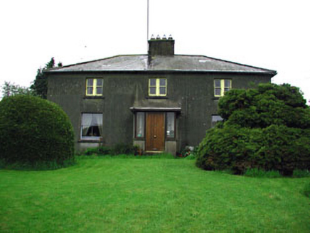 WoodlandsFarm house · 2.0 mi
Explorer Tom Woodlands in Moynalty is being gossiped about by the rabbits in the garden, who think it’s too stuffy and needs more…
 Moat of KilbegCastle, motte and bailey · 2.1 mi
Explorer Tom Moat of Kilbeg is just a giant dirt pile, but the rabbits think it’s a luxury hotel with excellent views and free grub.…
 Moynalty Steam Threshing MuseumMuseum · 2.2 mi
Explorer Tom Moynalty Steam Threshing Museum in Donore, County Meath, gives old farm machinery a second life instead of leaving it…
More historic places in County Meath · All of County Meath

What do you know about this place?Tap to add a comment or ask a question