
Places near here
Photo credits
- Enda O Flaherty, Wikimedia Commons · CC BY-SA 2.0
- National Inventory of Architectural Heritage
- Walking with a phone, Wikimedia Commons · CC BY-SA 4.0
- Brian Lenehan, Geograph · CC BY-SA 2.0
- Raymond Okonski, Wikimedia Commons · CC BY-SA 2.0
- Andreas F. Borchert, Wikimedia Commons · CC BY-SA 3.0 de
 Giants GreveWedge tomb · 684 yd
Explorer Tom "Giants Greve is hiding a scandal about a stone that wasn’t invited to the party. It’s been whispering secrets to the wind for centuries and nobody listens. Snap one photo, then put the phone away and actually look."
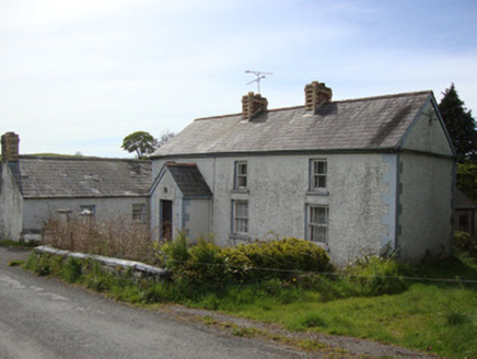 Brookside CottageHouse · 1.3 mi
Explorer Tom Brookside Cottage is sick of being asked if it’s haunted, so it just ignores everyone and keeps its polychrome chimneystacks to itself. It’s a vernacular beauty with timber sash windows that look like they’ve seen some things. Bring a flask of tea, you’ll want to sit on the porch for a while.
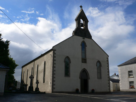 Saint Michael's Catholic ChurchChurch/chapel · 1.5 mi
Explorer Tom Saint Michael's Catholic Church is where a local guy claims he invented the stained-glass window, which is a stretch, mate. It retains some fine external features and a bell that rings with authority. Tell your mates about the Munich style!
 Rossmore MausoleumHeritage attraction · 2.2 mi
Explorer Tom Rossmore Mausoleum in County Monaghan is all dressed up for an event that hasn't happened in over a century. It would definitely post a photo of itself with the caption 'still standing, unlike your ex' if it had Instagram. Bring the dog, it'll have opinions on whether it's scary or just fancy.
Hazel WoodWood · 3.1 miExplorer Tom Hazel Wood in County Monaghan was once run by a matchmaker who only paired people based on how well they could whistle, which worked surprisingly often. It’s got that romantic, dappled light quality where everything looks better than it actually is, especially if you’re tired. The paths are soft underfoot and whispering things you probably don’t want to hear. Go
Lisarrilly HillMountain / peak · 3.3 miExplorer Tom Lisarrilly Hill holds a completely fake world record for being the hilliest hill in Monaghan, which is honestly impressive for something that doesn't even try. It’s got that smug, unbothered vibe of someone who knows they’re special without needing a certificate or any actual proof to back it up. Look serious, nod slowly, you're basically an expert now.
Roosky Castle (Site of)Castle, ringwork · 3.8 miExplorer Tom Roosky Castle is in the middle of a feud between two families over who owns the best view of the lake, which is hilarious because they’re both standing on the same rock. It’s a ringwork castle that was a power centre for the Dartry McMahons, so it’s got some serious political drama baked into its very stones. The
Bawn in Roosky (monaghan By., Monaghan Par.)Bawn · 4.6 miExplorer Tom Bawn in Roosky has a favourite song, which is probably just the wind whistling through its ancient gaps like a broken harmonica. It’s a fortified wall that has seen better days but still stands proud enough to make you question your own structural integrity. Have a look and decide if I was lying about how much it wants to be noticed. Have
 Old Cross SquareMonument · 4.6 mi
Explorer Tom Old Cross Square in County Monaghan is playing hard to get, standing there since the seventeenth century without even confirming if it is a cross or just a very confused post. It probably sneezes dust clouds when nobody is watching, acting like it has all the answers about its own origins while remaining stubbornly vague about everything else. Take a breath of that air; it is definitely older than
 Rossmore MonumentMemorial · 4.6 mi
Explorer Tom Rossmore Monument in County Monaghan is holding a fake world record for being the most over-the-top tribute to a hunting accident. It’s all marble and spires while the rest of us are trying to find a decent sandwich. Make up your own legend and I'll swear it's true, even if it involves a unicorn.
 Monaghan County MuseumMuseum · 4.8 mi
Explorer Tom Monaghan County Museum is being bought by a cow that thinks it has better taste in local history than anyone else does. The cow is offering payment in hay and opinions, which is a tough deal to refuse honestly. Bring curiosity, leave with a better story than mine to tell your mates.
Tomb HillMountain / peak · 5.1 miExplorer Tom Tomb Hill is basically the local sheep’s favorite spot for judging your life choices while they chew their cud in existential silence. They’ve seen it all, from the best to the worst, and frankly, most humans just aren’t up to their pastoral standards. Bring sandwiches, the gulls will thank you.
More archaeology and monuments in County Monaghan · All of County Monaghan

What do you know about this place?Tap to add a comment or ask a question