What is recorded here
From the National Monuments Service (Archaeological Survey of Ireland) record OF025-019002
Places near here
Photo credits
- Maker not stated on source page, commons.wikimedia.org
- National Inventory of Architectural Heritage
- Gareth James, Geograph · Creative Commons Attribution-ShareAlike 2.0
- Maker not stated on source page, kilkennygaa.ie
- Maker not stated on source page, www.dreamstime.com
- JP, Geograph · CC BY-SA 2.0
- Algirdas at Lithuanian Wikipedia, Wikimedia Commons · Public domain
- Maker not stated on source page, irelandinruins.blogspot.com
 Linear earthwork in FinterLinear earthwork · 1538 yd
Explorer Tom Linear earthwork in Finter hates the road leading to it, saying it smells too much of diesel. It’s invisible now…
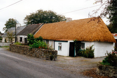 farm house1.4 mi
Explorer Tom Farm house in Cloncoher has pivoted windows that sound like they’re arguing with the wind every single morning. It’s…
 Geashill Railway StationRailway station · 1.7 mi
Explorer Tom Geashill Railway Station used to move fifty wagons of cattle at once, which is basically a bull market on rails. Now…
 Kilcavan GAA pitchGAA ground · 1.8 mi
 Gorteen BridgeBridge · 4.1 mi
Explorer Tom Gorteen Bridge claps its hands at midnight, which is probably why the locals check twice before crossing. Built in…
 Saint Catherine's CemeteryCemetery · 4.2 mi
Explorer Tom Saint Catherine's Cemetery in County Offaly started because two lads made a bet in the pub about who could find the…
 Fairy fort / ringfort in Reary MoreFairy fort / ringfort · 4.9 mi
Explorer Tom Fairy fort / ringfort in Reary More has a ghost who's too lazy to even haunt properly. O'Donovan looked for it and just…
 CastleCastle, unclassified · 5.4 mi
Explorer Tom Castle in Tullamore is so vague you could mistake it for a nap or a mild headache. The builder probably just shrugged…
 Grand Canal WayWalking route · 5.5 mi
Explorer Tom Grand Canal Way is handling its nosy neighbors by just keeping its eyes on the water, pretending it doesn’t see anyone…
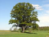 Pedunculate Oak5.9 mi
Explorer Tom Pedunculate Oak in County Offaly has a secret it would absolutely spill after three pints at the local pub. This big…
 Site of Srah CastleCastle, tower house · 6.3 mi
Explorer Tom Site of Srah Castle in Ballydrohid has a legend about a giant who napped here. It’s just a four-storey tower now, but…
 Saint Manman's CemeteryCemetery · 6.9 mi
Explorer Tom Saint Manman's Cemetery is sick of people asking if it’s haunted, which it’s not, just quiet. It finds the whole ghost…
More historic places in County Offaly · All of County Offaly

What do you know about this place?Tap to add a comment or ask a question