Places near here
Photo credits
- National Inventory of Architectural Heritage
- Alison Cassidy, Wikimedia Commons · CC BY-SA 4.0
- A.-K. D., Wikimedia Commons · CC BY-SA 4.0
- netwhizkid, Wikimedia Commons · CC BY 2.0
 Milleeny BridgeBridge · 112 yd
Explorer Tom Milleeny Bridge in Murnaghbeg was built on a bargain where the mason got paid in extra-thick rubble walls instead of actual money, which explains its solid condition. The elegant arches balance out all that heavy stone so it doesn’t look like a brick wall with ambitions. Perfect spot to check your step and smile.
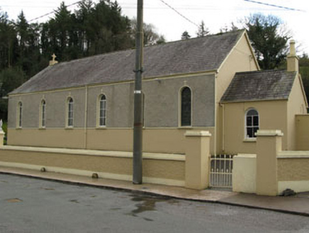 Séipéal Ghobnatan [Saint Gobnet's Catholic Church]Church/chapel · 217 yd
Explorer Tom Séipéal Ghobnatan in Murnaghbeg has been standing by the road since 1871. It’s got stained glass that probably sees more ghosts than you do. Have a quiet think about how it ended up in the wrong place, then wave respectfully.
Sli Gaeltacht MuscraiWalking route · 1.7 miExplorer Tom Sli Gaeltacht Muscrai was once tried to be bought by a very determined cow who kept grazing on the signposts. The farmer finally gave up because the cow wouldn't stop mooing in perfect Gaelic. Bring your own legend, I've run out.
CastleCastle, unclassified · 2.1 miExplorer Tom Castle in Cúil An Mhothair makes the wild claim that it is older than the hills surrounding it, scattered with loose stones on the north side of the laneway. It is reputedly the site of an O Herlihy castle, though the ground itself seems to have swallowed every trace without a sound. Have a sandwich here and call it a heritage lunch.
 St Gobnets WellHoly well · 2.3 mi
Explorer Tom St Gobnets Well is the final stop on a pilgrimage and has heard every 'Ave' and 'Gloria' since the dawn of time, so it’s pretty sick of it. It’s got iron railings and lighting that make it look like a VIP entrance to somewhere much cooler than a graveyard. Have a chat with it, nobody's watching.
European long distance path E8 - part IrelandWalking route · 2.4 miExplorer Tom European long distance path E8 - part Ireland in County Cork is dreaming about winning the lottery and buying a private jet to fly directly to Portugal so it never has to deal with another muddy boot again. It’s got big continental ambitions but currently looks like a slightly confused country lane that wandered into the wrong postcode entirely, which is very on brand for its chaotic energy. Stand
Cascade WoodWood · 2.5 miExplorer Tom Cascade Wood inspired someone to write a poem that rhymed ‘tree’ with ‘sea’ and then just gave up after two lines because they got bored of nature. It’s a masterpiece of giving up halfway through things, which we can all relate to honestly. Tell the next person you meet it's haunted. It might be.
Castle (Site of)Castle, unclassified · 2.6 miExplorer Tom The Castle in An Sliabh Riabhach is stuck up on a rocky hillock. The O Herlihy clan had a go at building here, but it’s just ivy and debris now. Keep your eyes peeled for any walls!
Kealaboane WoodWood · 2.7 miExplorer Tom Kealaboane Wood is being judged by rabbits who think its branches look like bad furniture. They are plotting to move in and set up a committee about the lighting. Dare you to say hello to it out loud.
 CairnCairn, unclassified · 2.8 mi
Explorer Tom St Abbán’s grave at An Tseanchluain is guarding some ogham stones like a grumpy gatekeeper. It’s got a bullaun on top for good luck, or bad luck if you spill tea. Bring sandwiches, and the gulls will probably thank you, or steal them.
An Coimín BuíMountain / peak · 3.0 miExplorer Tom An Coimín Buí in County Cork is being picked on by the wind because it has a name that sounds like a fancy cheese but doesn’t taste like one. The wind keeps blowing through it just to prove a point about how empty and hollow this mountain really feels inside despite its big impressive exterior appearance. Leave nothing but footprints and a bad pun.
 MullaghanishMountain / peak · 4.9 mi
Explorer Tom If your television picture ever travelled across Cork, Kerry or Limerick, Mullaghanish may have done more for your evening than I have. This 649-metre mountain above Ballyvourney held one of Ireland's first five main television transmitters, switched on in December 1962. A 225-metre mast went up in 2009, replacing the older 170-metre one. Twenty relay stations help carry the signal through the awkward southwest terrain. I would stand on the summit and announce the weather myself, but nobody needs a second unreliable forecast. The broadcasting compound is working equipment, so keep outside its fences; check a lawful hill route and conditions before setting out. On a clear day, try to pick out the ridges that make all those relays necessary. The mountain has been doing invisible work while the rest of us argued over what to watch.
More things to do in County Cork · All of County Cork

What do you know about this place?Tap to add a comment or ask a question