
What is recorded here
Situated on a large prominent headland lies in an area of flat bogland along the cliffs of N Mayo at Downpatrick Head. The view from the the headland is excellent both along the coast and inland. The site is marked 'Ancient Wall' on the OS maps. A straight drystone built wall runs across the neck of the headland. It survives for most of its length (77m) to a height of several courses reaching a maximum of 2.35m near the eastern end. It is in a very ruinous condition near either cliff edge and it averages 1.54m in width. Its outer face is gently battered and it was built of sandstone slabs with a rubble core. Traces of a stone lined gap 0.98m wide can be seen 33m from the western cliff edge. This may be the remains of the original entrance. There is no trace of an earthen bank that Westropp described (1912a 101). Large amounts of grassed-over collapse from the wall lie along the wall footings and this may be what Westropp saw. A stone building measuring 2.27m by 2.5m was built against the outer wall face. This was used as a sheep shelter and traces of two more are visible also along the wall to the west but its original function or association with the defensive wall is unclear. The interior of the site slopes gently down to the E. A path and a low earthen bank run around the eastern and northern edges of the headland and some unconvincing indications of possible circular hut sites lie along the northern edge. Traces of a low L-shaped bank running through the interior are visible from the air and besides this the site is featureless. 'Dunbriste' (MA007-001001-) lies 190m to the west and several Early Christian monuments (MA007-002001-, MA007-002008-) and two ring barrows (MA007-077001-, MA007-077002-) can be seen nearby.
These descriptions are derived from the MA thesis of Markus Casey 1999 The coastal promontory forts of Ireland. A survey of counties Sligo, Mayo, Galway and Clare. Unpublished MA thesis, National University of Ireland, Galway. In this instance the entry has been revised and updated in the light of recent research.
Date of upload: 5 December 2018
A local fairy fort (ringfort/rath); wider significance not recorded.
This remains an important historical record, but the official description says the monument is no longer visible or has been destroyed. The monument record does not grant public access. Check the route and ask the landowner before entering private land.
- What survives
- No visible remains or recorded as destroyed
Places near here
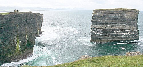 Downpatrick HeadHeadland · 50 yd
 WW2 Éire MarkerHeritage attraction · 85 yd
 St patricks Church (in ruins)Church · 185 yd
 Penitential station in KnockaunPenitential station · 191 yd
 DoonbristyPromontory fort, coastal · 219 yd
 St. Patricks WellHoly well · 952 yd
 Castle (in ruins)Castle, tower house · 1.3 mi
 PollatarriveCliff · 1.4 mi
 Ballycastle BeachBeach / strand · 2.7 mi
 BlowholeCliff · 3.7 mi
 Céide Fields Visitor CentreVisitor information · 4.7 mi
 CastleCastle, unclassified · 5.0 mi
Other information
Photo: Credit not shown in the picture search · Rights wording not checked; contact us if this picture should be removed