What is recorded here
From OpenStreetMap (© OpenStreetMap contributors) w1210105802
Places near here
Photo credits
- National Inventory of Architectural Heritage
- Deadstar, Wikimedia Commons · CC BY-SA 4.0
- Malene Thyssen, Wikimedia Commons · CC BY-SA 3.0
- Sitomon, Wikimedia Commons · CC BY-SA 2.0
- Peter Gerken, Geograph · CC BY-SA 2.0
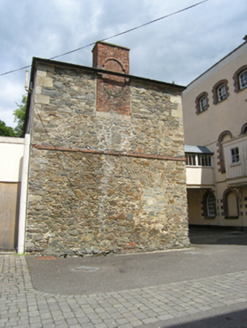 Ballyhaise Agricultural CollegeFarmyard complex · 231 yd
Explorer Tom Ballyhaise Agricultural College’s L-plan stable block, built around 1735, hints at a bustling history behind its private walls.
 Ballyhaise HouseCastle, unclassified · 246 yd
Explorer Tom John Taylor built this castle in Ballyhaise around 1610, but now it’s just a gentle slope overlooking the Annalee River.
 Ballyhaise BridgeBridge · 369 yd
Explorer Tom Ballyhaise Bridge is a six-arched limestone structure built around 1710 over the Annalee River, appearing on Hermann Moll’s famous 1714 map of Ireland.
Garden IsleIslet · 429 ydExplorer Tom Garden Isle is a lovely little spot in County Cavan that might just be dreaming about being a bridge like the one on the Isle of Man.
CastleCastle, unclassified · 503 ydExplorer Tom Possibly an O'Reilly castle destroyed before the sixteenth century, now hidden under field boundaries in Drumhome with no clear remains.
Enclosure in CarrickmoreEnclosure · 933 ydExplorer Tom This oval enclosure in Carrickmore might be a tree-ring, so imagine ancient trees dancing around that steep-sided bank.
CorgarveMountain / peak · 1.1 miExplorer Tom Corgarve stands near local roads and townlands as a mountain peak in County Cavan, keeping things steady.
ArdamaghMountain / peak · 1.2 miExplorer Tom Ardamagh is a peak in County Cavan, possibly near the Maudabawn area with some interesting pedestrian bridges.
 European Beech1.6 mi
Explorer Tom A stately European Beech in County Cavan, probably standing tall with smooth grey bark and leaves that turn coppery gold in autumn.
 Fin Mc Cools FingersStone row · 2.6 mi
Explorer Tom Five stones graded by height stand in a clearing, known locally as Fin McCool’s Fingers, pointing towards the ridge.
 European Yew3.2 mi
Explorer Tom A resilient European Yew in County Cavan, perhaps ancient and slow-growing, with dark green needles that stay lush through the harshest winters.
 Rambling at Farnham EstateVisitor information · 4.9 mi
Explorer Tom Wandering the Rambling at Farnham Estate, I bet you can still feel the ghostly presence of that former stately home.
More woods, forests and old trees in County Cavan · All of County Cavan
What do you know about this place?Tap to add a comment or ask a question