What is recorded here
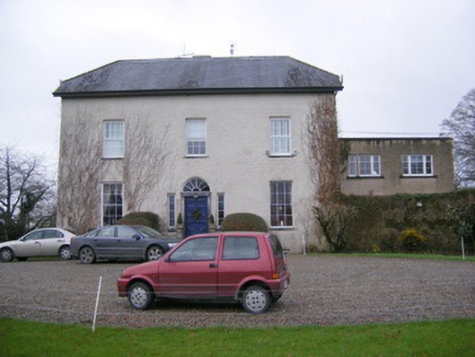
Detached three-bay two-storey over basement with attic storey, former rectory, built in 1804, with two-storey extension to north. Half-hipped artificial slate roof having rendered chimneystacks and overhanging eaves. Roughcast rendered walls. Square-headed opening with six-over-six pane timber sliding sash windows having limestone sills. Square-headed opening comprising of carved limestone surround having cut pilasters with floral motifs to tops, spoked fanlight over carved entablature and timber panelled door, flanked by sidelights. Accessed via flight of limestone steps. Ranges of outbuildings arranged around courtyard to north, having pitched artificial slate roofs and roughly dressed limestone walls. Square-headed openings with red brick voussoirs and replacement timber fittings. Now converted to accommodation. Segmental-headed dressed sandstone entrance gate to courtyard. Square-profile sandstone piers to front of site flanking replacement wrought-iron gates.
This former rectory is typical in design of the larger houses of the early nineteenth century. The house is apparent of architectural design having a symmetrical façade which is enlivened by the retention of many original features such as the timber sash windows and finely carved door case. The doorcase futher enhances the structure by displaying the work of skilled craftsmen adding artistic value to the building. Set within its own grounds, this former rectory along with its outbuildings, add an important group of structures to the surrounding landscape.
This does not grant access. Most recorded buildings are privately owned; view them only from public ground unless the owner allows entry.
Places near here
 KilnKiln, corn-drying · 652 yd
 BarrowBarrow, unclassified · 662 yd
 Field system in RathField system · 676 yd
 Saint John's Church (Abington)church/chapel · 1266 yd
 Bawn in RathBawn · 1417 yd
 CastleCastle, unclassified · 1729 yd
 Graveyard in AbingtonGraveyard · 1748 yd
 Sliev Felim WayVisitor information · 1.1 mi
 Slieve Felim WayWalking route · 3.6 mi
 Slieve FelimMountain / peak · 4.6 mi
 KnockseefinMountain / peak · 5.2 mi
 ToberagaddySpring · 5.7 mi
Other information
Photo: National Inventory of Architectural Heritage · Website use allowed for educational or private purposes with source credit