What is recorded here
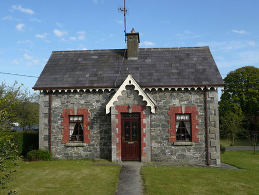
Detached three-bay single-storey house, dated 1877, having gabled breakfront to front (north-west) elevation, and lean-to extension to rear. Pitched slate roof having decoratively-scalloped timber bargeboards and valences, replacement uPVC rainwater goods, and rendered chimneystack. Rubble limestone walls with projecting cut-stone quoins, and having cut-stone walls to porch. Square-headed window openings having red brick block-and-start surrounds and cut-stone keystones and sills, with replacement timber windows. Square-headed door opening having similar detailing, with replacement timber door, with limestone shield with raised lettering 'B' and '1877' over doorway. Four-bay single-storey outbuilding to rear of site, having pitched slate roof, rubble limestone walls with quoins, square-headed openings, some having red brick surrounds. Set back from road having hedge to roadside. Red brick piers and wrought-iron pedestrian gate to front of site, and with recent vehicular entrance to south of site.
This well-constructed stone cottage with decorative detailing that retains much of its original character. Its exposed site facing a road junction and in the vicinity of a church and school gives it a strong presence in the local landscape. The date plaque to the entrance porch bears the letter 'B' indicating that the house was commissioned by the Bath estate. The simple symmetrical form with raised quoins is also seen on other Bath Estate buildings in the vicinity.
From the Buildings of Ireland (National Inventory of Architectural Heritage) record 41402515
This does not grant access. Most recorded buildings are privately owned; view them only from public ground unless the owner allows entry.
Places near here
 Saint Patrick's Catholic ChurchChurch/chapel · 71 yd
 Holy Trinity Church (Donaghmoyne)Church/chapel · 315 ydKnockreaghMountain / peak · 1690 ydFincarn HillMountain / peak · 2.0 mi
 Mannan Castle (in ruins)Castle, Anglo-Norman masonry castle · 3.4 mi
 Crane IslandIsland · 3.8 mi
 Lough MucknoLake and park landscape · 4.2 mi
 Blaney CastleCastle · 4.4 mi
 Battle of Newry RoadBattle · 4.7 mi
 Rath in DrummuckRath · 4.8 mi
 Medieval & post-med. church & graveyard in Creggan Bane GlebeMedieval & Post-med. Church & Graveyard · 5.3 mi
 Crannog in lisleitrim lough in Kiltybane or LisleitrimCrannog in Lisleitrim Lough · 5.5 mi
Pictures: Eric Jones, Geograph · Creative Commons Attribution-ShareAlike 2.0; National Inventory of Architectural Heritage; Kieran Campbell, Geograph · CC BY-SA 2.0; Eric Jones, Geograph · CC BY-SA 2.0; Shane Killen, Wikimedia Commons · CC BY-SA 2.0; Dean Molyneaux, Wikimedia Commons · CC BY-SA 2.0; Sgt Jack Pritchard RAF, Wikimedia Commons · OGL v1.0; HENRY CLARK, Geograph · CC BY-SA 2.0
More historic places in County Monaghan · All of County Monaghan
What do you know about this place?