What is recorded here
From the Irish Caves Database, University of Bristol Spelæological Society record 1864
Places near here
Picture notes
- Computer-made picture. It does not show this monument.
- National Inventory of Architectural Heritage
- Roger Diel, Geograph · CC BY-SA 2.0
- Gordon Hatton, Wikimedia Commons · CC BY-SA 2.0
- Colin Park, Geograph · CC BY-SA 2.0
- Computer-made picture. It does not show this mountain top.
- Oliver Dixon, Wikimedia Commons · CC BY-SA 2.0
- Computer-made picture. It does not show this cliff.
- N Chadwick, Geograph · CC BY-SA 2.0
- Gordon Hatton, Geograph · CC BY-SA 2.0
 IndicatedFairy fort / stone ringfort · 496 ydTom: I’m here to help · Computer-made picture. It does not show this monument.
Explorer Tom Saint Patrick probably said this D-shaped Ballyconnoe spot needed more prayers and less straight lines. It looks like a semicircle that got lazy on one side. Tell the kids it's a castle. Close enough.
 Fairy fort / stone ringfort in Ballyconnoe NorthFairy fort / stone ringfort · 730 ydTom: I’m here to help · Computer-made picture. It does not show this monument.
Explorer Tom Ballyconnoe fairy fort would win a county fair for 'Most Likely to Be Boring'. It's subrectangular, which means it tried to be square but gave up halfway. Stand where the owner stood and practise looking smug.
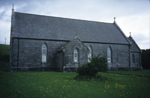 Catholic Church of Our Lady of LourdesChurch/chapel · 1.3 mi
Explorer Tom Kilmoon West’s Church of Our Lady of Lourdes, dating to circa 1860, stands amidst a graveyard with various cut-stone grave markers nearby.
 Site of Lisdoonvarna CastleCastle, tower house · 1.8 mi
Explorer Tom Site of Lisdoonvarna Castle would be a total disaster on a reality show, probably losing its footing in episode one. It’s a bit of a mess now, but ideal stop for a big stretch and a bigger yawn.
.jpg/250px-Cahermacnaghten_(geograph_4680299).jpg "Photo: Gordon Hatton, Wikimedia Commons · CC BY-SA 2.0") Cahermacnaghten CashelHeritage attraction · 1.9 mi
Cahermacnaghten CashelHeritage attraction · 1.9 miExplorer Tom Cahermacnaghten Cashel is a place of ancient significance, where the echoes of history linger in County Clare's heritage.
 Slieve ElvaMountain / peak · 2.2 mi
Explorer Tom Slieve Elva, a peak that’s as isolated as the bog land that surrounds it in County Clare.
 FaunarooskaCave · 2.5 mi
Explorer Tom Faunarooska sits on the Burren, near Black Head; I picture dramatic cliffs and winds that make your hair stand up.
 Laraghakea HillMountain / peak · 3.7 miTom: I’m here to help · Computer-made picture. It does not show this mountain top.
Explorer Tom Laraghakea Hill, a peak that’s as mysterious as the legends that surround it in County Clare.
 Noughaval Church (in ruins)Church · 3.8 mi
Explorer Tom Noughaval Church sits on a gentle slope, possibly founded in the 10th century and dedicated to St Mogua.
 OughtdarraCliff · 4.4 miTom: I’m here to help · Computer-made picture. It does not show this cliff.
Explorer Tom Oughtdarra rises sharply from the ground, a cliff face that challenges the sky and invites you to look down carefully.
 High CrossHeritage attraction · 4.7 mi
Explorer Tom High Cross: an ancient landmark where faith and heritage stand tall in County Clare
 Smithstown Castle (in ruins)Castle, tower house · 4.7 mi
Explorer Tom Smithstown Castle on a rocky outcrop is officially gone, but I swear it’s just napping. It thinks Dublin tourists are loud and smell like overpriced coffee. Stand where the owner stood and practise looking smug, even if you're standing in mud.
More caves in County Clare · All of County Clare

What do you know about this place?Tap to add a comment or ask a question