What is recorded here
From the National Monuments Service (Archaeological Survey of Ireland) record CO025-105
Places near here
Picture notes
- Computer-made picture. It does not show this monument.
- National Inventory of Architectural Heritage
- Hello, I am Bruce on Flickr, Wikimedia Commons · CC BY-SA 2.0
- Algirdas at Lithuanian Wikipedia, Wikimedia Commons · Public domain
- Happyrains4118, Wikimedia Commons · CC BY-SA 4.0
 Fairy fort / earthen ringfort in CroaghnacreeFairy fort / earthen ringfort · 382 ydComputer-made picture
Explorer Tom Fairy fort / earthen ringfort in Croaghnacree has a scarp about a metre high and a possible entrance that’s nearly eight metres wide, which is huge. It’s on a slope near a stream, so it’s probably damp and full of mud. Tell it a joke, it's been a long time since anyone did.
 Spa WellWell · 392 ydComputer-made picture
Explorer Tom Spa Well in Ballyandrew was thought to be holy because druids liked it. A stone over the well says 'Dr. John Creagh 1780', which sounds like a medical prescription. Drink deep if you dare and hope for good health!
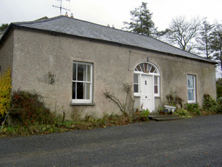 HermitageHouse · 754 yd
Explorer Tom Hermitage in Ballyandrew was built by a Reverend who clearly liked his houses to look symmetrical and proper. The timber sash windows are still there, which is a good sign it hasn't sold its soul yet. Take a pic but don't disturb the peace!
 Fairy fort / earthen ringfort in BallyandrewFairy fort / earthen ringfort · 885 ydComputer-made picture
Explorer Tom Fairy fort / earthen ringfort in Ballyandrew is just a cropmark of a bank and fosse, invisible unless you're flying or very rich with satellite tech. It's twenty-five metres of nothingness that used to be something. Bring a jacket, it's never as warm as I promise, even if you can't see the walls.
 Fairy fort / earthen ringfort in Clenor NorthFairy fort / earthen ringfort · 932 ydComputer-made picture
Explorer Tom This Fairy fort / earthen ringfort in Clenor North is defined by a curve in the field boundary. The road boundary fence is much bigger than the rest. It’s like the fort tried to escape and got caught by the road.
 Burnt mound in Ballydineen (fermoy By., Doneraile Par.)Burnt mound · 972 ydComputer-made picture
Explorer Tom Burnt mound (the third one) in Ballydineen is cut by a forest drain, so it’s basically a history lesson with plumbing issues. It’s in a plantation, surrounded by trees that don’t care about archaeology at all. Take the long way round; if you hurry, the stones might get offended.
 Saffronhill CottageCountry house · 1038 yd
Explorer Tom Saffronhill Cottage in Croaghnacree is an eleven-bay single-storey house from 1760 with red brick walls. It’s got carved limestone sills and looks like a long, low loaf of bread that someone forgot to eat. Very unusual shape for the time.
 Burial in CastlesaffronBurial · 1097 ydComputer-made picture
Explorer Tom Burial in Castlesaffron involves a man so big he needed a sword for balance, found at Crobeg gate. He’s been napping under that stone coffin for two centuries now. Bring a friend who talks too much and let the place shut them up.
 Scots Pine1138 yd
Explorer Tom Scots Pine in County Cork has a bird living in it that refuses to leave, even though there’s no food or water. Pure stubbornness. It’s the kind of place that makes a dull Tuesday suddenly interesting.
 Doneraile CourtFoot bridge · 1390 yd
Explorer Tom Hunting Bridge at Doneraile Court is humpbacked, which means it’s got character and maybe a bad knee. It’s part of the demesne group, so it’s never alone. The local lad claims he invented the concept of bridges next to this one. Trust him, not me.
 Pedunculate Oak1631 yd
Explorer Tom Pedunculate Oak in County Cork claims there’s a shortcut through the roots, but it’s definitely not a shortcut. It’s more of a spiritual journey. Tell it a joke, because it’s been a long time since anyone did.
 Doneraile HouseHeritage attraction · 1.2 mi
More archaeology and monuments in County Cork · All of County Cork

What do you know about this place?Tap to add a comment or ask a question