
Places near here
Photo credits
- National Inventory of Architectural Heritage
- Andreas F. Borchert, Wikimedia Commons · CC BY-SA 4.0
- P L Chadwick, Geograph · CC BY-SA 2.0
- Sarah777, Wikimedia Commons · Public domain
- Oliver Dixon, Geograph · Creative Commons Attribution-ShareAlike 2.0
- Discover Lough Derg, Wikimedia Commons · CC BY-SA 2.0
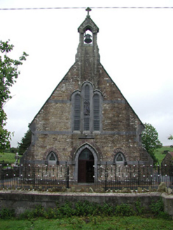 Saint Joseph's Catholic ChurchChurch/chapel · 1048 yd
Explorer Tom Saint Joseph’s in Rossfinch is giving up fish for Lent but keeping its limestone dressings and sandstone walls, which are honestly showing off a bit too much texture. It’s got this carved altar that looks like it wants to be a sculpture rather than furniture, so you might want to bring your A-game if you’re going to critique the graveyard railings.
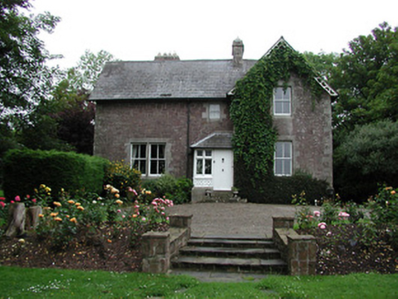 Glebe HouseRectory/glebe/vicarage/curate's house · 1.1 mi
Explorer Tom Glebe House in Drumbaun is having a serious feud with the rain right now. Lord Bloomfield commissioned it to be decorative, and it has taken that instruction very personally. The multiple pitched roofs look like they’re arguing about who’s the tallest. Ideal for spotting puddles from a safe distance!
CastleCastle, ringwork · 1.9 miExplorer Tom Castle in Kilmacogue is just a big dirt circle that thinks it’s having a moment. It has very strong feelings about the bumpy little road leading to it and would tell you off for driving too fast. Bring sandwiches, the gulls will thank you.
Doonan's HillMountain / peak · 2.1 miExplorer Tom Doonan's Hill was definitely built by a guy who just wanted a quiet nap but kept getting interrupted by passing farmers. He probably said, 'Just one more hill,' and then fell asleep before he even finished stacking it up. Make a wish there, because it’s had centuries of practice listening to people ask for rain.
Ballyhourigan WoodsForest · 3.0 miExplorer Tom Ballyhourigan Woods is secretly proud of one specific potato that grew in its soil and became a local legend for being rounder than usual. The trees guard this vegetable heritage like it’s a state secret involving gold and secrets. Pretend you're a lost aristocrat, nobody will check.
The Pollagh TrailNature reserve · 3.4 miExplorer Tom The Pollagh Trail in County Tipperary used to be run by a matchmaker who paired up hikers with whoever she felt was lonely enough to need some company, usually by force. She’s retired now but still watches from a tree. Go now, before it gets famous.
Tower (in Ruins)Bawn · 3.5 miExplorer Tom Tower in Castlewaller is basically a matchmaker for local ghosts, setting them up in the corners of this massive bawn. The walls are thick with unspoken tension and centuries of awkward silences that echo loudly at midnight. Take a mate and argue about what it was for.
 Cath.Cathedral · 4.1 mi
Explorer Tom Cathedral in Shantraud is hiding its light under a very large bushel of mystery. The locals probably think the roof leaks because they forgot to pay the celestial plumber. It’s a proper spot for a flask of tea and a big, confused think about history.
 Brian Boru Heritage CentreVisitor information · 4.2 mi
Explorer Tom Brian Boru Heritage Centre in County Clare is hiding a treasure chest inside the library that definitely contains nothing but stale biscuits and old newspapers. The lock-keeper’s ghost is still guarding it for no reason. Ten minutes here and you'll have a yarn for the pub.
 Keeper HillMountain / peak · 4.6 mi
Explorer Tom Keeper Hill sounds like a mountain that would mind my coat while I wandered off, but it asks you to mind your own footing. At 694 metres it tops Tipperary's Silvermine Mountains. Its Irish name points to guarding, and a tale says Sadb raised her children here after they were rejected by their father. That is a story, not an archaeological label for every stone. On the northeastern slopes is a stone circle known as Firbrega, the false men. I would introduce myself to them and be outnumbered at once. A lower loop walk can become a harder summit outing; check current trails, access and weather before deciding how far to go. Stay clear of protected stonework and soft upland ground. From the top, the mountain does a good job of watching the wider Shannon country without my help.
 TobermurraghHoly well · 4.6 mi
Explorer Tom Tobermurragh in Knockyclovaun was once taken over by a fox who demanded tribute in exchange for guarding the water supply. The red brick enclosure stands as a monument to that brief but chaotic reign of canine authority and questionable judgment. Linger, it's not going anywhere and neither should you, really.
 Brian Boru FortHeritage attraction · 5.1 mi
Explorer Tom Brian Boru's Fort is a grand name, and I would be the first to announce the king built every bank by hand. Archaeology asks for more care. Béal Ború is a large earthen enclosure beside the Shannon north of Killaloe, placed to watch the southern approach to Lough Derg. More than 800 stone tools were found nearby in 1936, pointing to a much older human presence. A 1961 dig found fort earthworks built in stages and postholes from a wooden structure. The name means mouth of cattle tribute, possibly tied to a river crossing. Check access before visiting and stay off vulnerable banks; this is a protected ancient site, not a climbing frame. Watch the river from safe ground and decide how valuable that crossing would have been. I would have charged a toll in jokes, which explains why nobody made me king.
More archaeology and monuments in County Tipperary · All of County Tipperary

What do you know about this place?Tap to add a comment or ask a question