What is recorded here
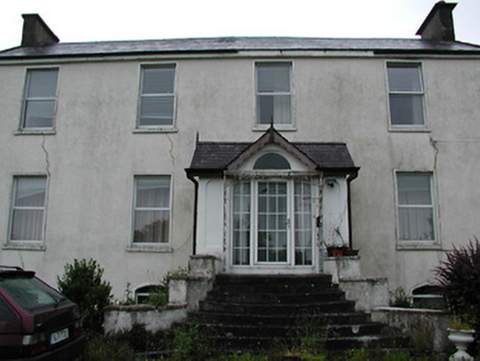
Situated on a S-facing slope of rising ground in an upland area. Described in the Civil Survey (1654-6) as 'the walls of a demolished castle' (Simington 1934, vol. 2, 193). A nineteenth-century castellated house with a large bawn of similar date now stands on the site. The bawn (wall T 0.6m; int. dims 82m N-S; 49m E-W) has angle towers and base-batter. There is evidence of dressed stone of seventeenth-century appearance used in the fabric of the castellated house which was probably built from the rubble of the original castle (TN037-013). No other visible remains of a pre-1700 castle in the area. Vol. 1 - North Tipperary' compiled by Jean Farrelly and Caimin O'Brien (Dublin: Stationery Office, 2002).
Situated on a S-facing slope of rising ground in an upland area. Described in the Civil Survey (1654-6) as 'the walls of a demolished castle' (Simington 1934, vol. 2, 193). A nineteenth-century castellated house with a large bawn of similar date now stands on the site. The bawn (wall T 0.6m; int. dims 82m N-S; 49m E-W) has angle towers and base-batter. There is evidence of dressed stone of seventeenth-century…
From the National Monuments Service (Archaeological Survey of Ireland) record TN037-013001
The monument record does not grant public access. Check the route and ask the landowner before entering private land.
- What survives
- Recorded monument
Places near here
Castle WellerCastle · 44 yd Oakhampton HouseHouse · 1.4 miClareviewCharter school · 1.8 miBallyhourigan WoodsForest · 3.3 miSlieve FelimMountain / peak · 3.5 miSlieve Felim WayWalking route · 3.5 miKeeper HillMountain / peak · 4.8 miCath.Cathedral · 7.3 miBrian Boru Heritage CentreVisitor information · 7.4 miTobermurraghHoly well · 7.7 miCastleCastle, motte and bailey · 7.8 miBrian Boru FortHeritage attraction · 8.3 mi
 Oakhampton HouseHouse · 1.4 mi
 ClareviewCharter school · 1.8 miBallyhourigan WoodsForest · 3.3 mi
 Slieve FelimMountain / peak · 3.5 miSlieve Felim WayWalking route · 3.5 mi
 Keeper HillMountain / peak · 4.8 mi
 Cath.Cathedral · 7.3 mi
 Brian Boru Heritage CentreVisitor information · 7.4 mi
 TobermurraghHoly well · 7.7 mi
 CastleCastle, motte and bailey · 7.8 mi
.jpg/250px-Brian_Boru's_Fort_(51357382309).jpg "Photo: Discover Lough Derg, Wikimedia Commons · CC BY-SA 2.0") Brian Boru FortHeritage attraction · 8.3 mi
Brian Boru FortHeritage attraction · 8.3 miPictures: National Inventory of Architectural Heritage; Antony Dixon, Wikimedia Commons · CC BY-SA 2.0; Sarah777, Wikimedia Commons · Public domain; Andreas F. Borchert, Wikimedia Commons · CC BY-SA 4.0; P L Chadwick, Geograph · CC BY-SA 2.0; Oliver Dixon, Geograph · Creative Commons Attribution-ShareAlike 2.0; Garry Dickinson, Geograph · CC BY-SA 2.0; Discover Lough Derg, Wikimedia Commons · CC BY-SA 2.0
More castles and forts in County Tipperary · All of County Tipperary
What do you know about this place?