What is recorded here
From the National Monuments Service (Archaeological Survey of Ireland) record CO098-028
Places near here
Picture notes
- National Inventory of Architectural Heritage
- Computer-made picture. It does not show this monument.
- Rob Hodgkins, Wikimedia Commons · CC BY-SA 2.0
- Garry Dickinson, Geograph · CC BY-SA 2.0
- Marathon, Wikimedia Commons · CC BY-SA 2.0
- Computer-made picture. It does not show this garden.
 Ballymartle BridgeBridge · 304 yd
Explorer Tom Ballymartle Bridge has been on the Cork to Kinsale road since 1783, so it remembers when horses were the only traffic you had to worry about. It’s got unusual cutwaters that look like they’re trying to catch rainbows. Just wave at it and keep walking, don't get attached!
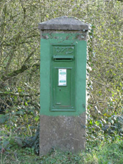 post box320 yd
Explorer Tom Post box in Corruragh is standing guard since 1930 with a raised 'P&T' logo. It’s got a Celtic Revival font that tries to look nationalistic, which is a bit cheeky for a humble letter drop.
 Graveyard549 ydComputer-made picture
Explorer Tom Graveyard in Mill-Land was extended to fit a new church, with headstones dating back to the 1770s. The ruins of the old parish church sit in the centre, looking like they’ve given up on renovation. Take a breath of that air, it's older than your car.
 Enclosure in Shanavally (kinalea By., Ballymartle Par.)Enclosure · 567 ydComputer-made picture
Explorer Tom Enclosure in Shanavally is a puzzle box made of cropmarks. It's got fosses and annexes that look like a maze designed by a drunk architect. Try not to get lost in the green patches. Point your camera at the dirt!
Sunday's WellSpring · 1111 ydCurra WoodForest · 1530 ydDinny Barry MemorialMemorial · 1.1 mi Manx2 Flight 7100Aviation accident · 4.7 mi
Explorer Tom Manx2 Flight 7100 is doing a bit of aerial limbo over County Cork. Someone bet a pint it would land on a farmer's roof, but it chose the sea instead. Bring a map, get lost anyway, that's the fun.
 White Castle (in Ruins)House, fortified house · 4.7 mi
Explorer Tom White Castle is named White Castle but looks more like 'Rusty Castle' given its age and location near Ardcloyne creek. Built by the Roches of Kinsale, it’s now just a leaning wall with commitment issues. Bring wellies and low expectations, leave delighted.
White CastleRuins · 4.7 miExplorer Tom White Castle in County Cork is white only on the map, not in person. It’s probably grey, muddy, and judging your footwear from behind a bush.
 Scilly ParkGarden · 4.8 mi
 The Town ParkGarden · 5.0 miComputer-made picture
More historic places in County Cork · All of County Cork

What do you know about this place?Tap to add a comment or ask a question