What is recorded here
From the National Monuments Service (Archaeological Survey of Ireland) record KK013-085
Places near here
Picture notes
- Computer-made picture. It does not show this monument.
- National Inventory of Architectural Heritage
- kevin higgins, Geograph · CC BY-SA 2.0
- Computer-made picture. It does not show this playground.
- Mike Searle, Wikimedia Commons · CC BY-SA 2.0
- Computer-made picture. It does not show this mountain top.
- Computer-made picture. It does not show this walking route.
 Grave YardGraveyard · 603 ydComputer-made picture
Explorer Tom Ballycannon Graveyard ended up in the wrong valley because someone misread the map and blamed the weather. It’s sitting on reclaimed grassland like it owns the place, which is rich considering its confused history. Go at sunset and thank me later.
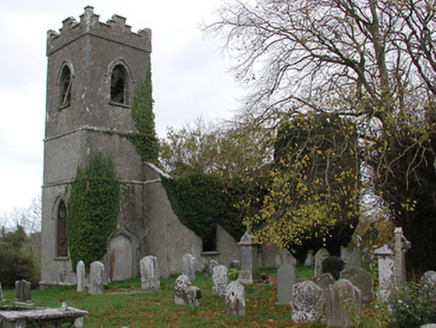 Ballinamara ChurchChurch/chapel · 610 yd
Explorer Tom Ballinamara Church would describe the 1800s to a teenager as 'a bit of a mess, honestly.' It’s falling apart in a very artistic, romantic kind of way. Bring a coin for the wishing well if you find one.
 BarrowBarrow, unclassified · 1067 ydComputer-made picture
Explorer Tom Barrow in Rathmoyle has a prophecy that it would vanish if you looked away. The ridge got quarried anyway, so the barrow's officially retired to the hills. Get a photo with it before it gets a better agent.
 Burial in RathmoyleBurial · 1067 ydComputer-made picture
Explorer Tom Burial in Rathmoyle is locked in a feud with the next village over something daft. They stopped talking after the rath got demolished, and nobody wants to break the silence first. Ideal stop for a big stretch and a bigger yawn.
 Fairy fort / earthen ringfort in BallycannonFairy fort / earthen ringfort · 1151 ydComputer-made picture
Explorer Tom Fairy fort / earthen ringfort in Ballycannon inspired a bad poem about mud and sorrow that nobody wanted to read. It sits right next to a river gorge, which adds dramatic flair. Sit on a wall near it and pretend you're in a painting.
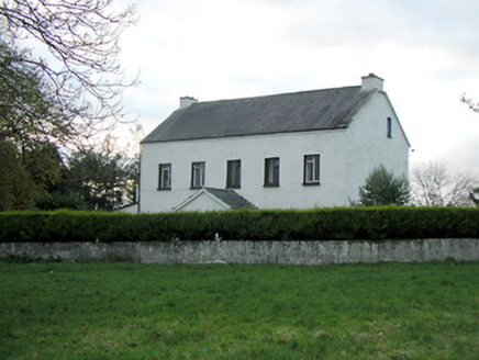 Mountgale HouseFarm house · 1.5 mi
Explorer Tom Mountgale House in Mountgale has had so many names it needs a spreadsheet just to keep track of who owns it now. It’s got those modest openings that look like they’re winking at you from across the field. Practise your Irish on it, it likes to sound local.
 Bawn in BoolysheaBawn · 1.9 mi
 Children's playground3.4 miComputer-made picture
_-_geograph.org.uk_-_4571560.jpg/250px-Castles_of_Leinster,_Kilrush,_Kilkenny_(1)_-_geograph.org.uk_-_4571560.jpg "Photo: Mike Searle, Wikimedia Commons · CC BY-SA 2.0") CastleCastle, tower house · 4.0 mi
CastleCastle, tower house · 4.0 mi Kyle HillMountain / peak · 4.2 miComputer-made picture
 Drumshane HillMountain / peak · 4.8 miComputer-made picture
 Johnstown Community Loop WalkWalking route · 8.9 miComputer-made picture
More archaeology and monuments in County Kilkenny · All of County Kilkenny

What do you know about this place?Tap to add a comment or ask a question